
Fil:EasternRomanEmpire.png
Der findes ingen højere opløsning af billedet
EasternRomanEmpire.png (250 × 175 billedpunkter, filstørrelse: 7 KB, MIME-type: image/png)
|
|
Denne fil er fra Wikimedia Commons. Beskrivelsen af filen fra Commons er gengivet nedenfor. |

|
This map has been uploaded by Electionworld from en.wikipedia.org to enable the |

|
Ejeren af dette billedes ophavsret tillader enhver at benytte det til et hvilket som helst formål herunder ubegrænset redistribution, kommercielt brug samt modifikation.
|
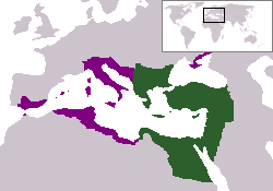
The territory in green represents the core areas held by the Eastern Roman Empire before the Muslim conquests The territory in purple represents the greatest extent of the Byzantine Empire under Emperor Justinian I
Filhistorik
Klik på en dato/tid for at se filen som den så ud på det tidspunkt.
| Dato/tid | Miniaturebillede | Dimensioner | Bruger | Kommentar | |
|---|---|---|---|---|---|
| nuværende | 13. dec. 2006, 20:27 | | 250 × 175 (7 KB) | Electionworld | {{ew|en|24630}} {{CopyrightedFreeUse-User|24630}} The territory in green represents the core areas held by the Eastern Roman Empire before the Muslim conquests The territory in purple represents the greatest extent of the Byzantine Empire unde |
Filanvendelse
Den følgende side bruger denne fil:
Global filanvendelse
Følgende andre wikier anvender denne fil:
- Anvendelser på en.wiktionary.org
- Anvendelser på gd.wikipedia.org
- Anvendelser på lv.wikipedia.org
- Anvendelser på no.wikipedia.org
- Anvendelser på ru.wiktionary.org
- Anvendelser på sl.wikipedia.org
- Anvendelser på sq.wikipedia.org
- Anvendelser på sv.wikipedia.org
- Anvendelser på vi.wikipedia.org
- Anvendelser på zh.wiktionary.org