
Fil:Gettysburg Day2 Wheatfield2.png
Størrelse af denne forhåndsvisning: 655 × 600 pixels. Andre opløsninger: 262 × 240 pixels | 524 × 480 pixels | 839 × 768 pixels | 1.118 × 1.024 pixels | 2.236 × 2.048 pixels | 3.931 × 3.600 pixels.
Fuld opløsning (3.931 × 3.600 billedpunkter, filstørrelse: 7,35 MB, MIME-type: image/png)
|
|
Denne fil er fra Wikimedia Commons. Beskrivelsen af filen fra Commons er gengivet nedenfor. |
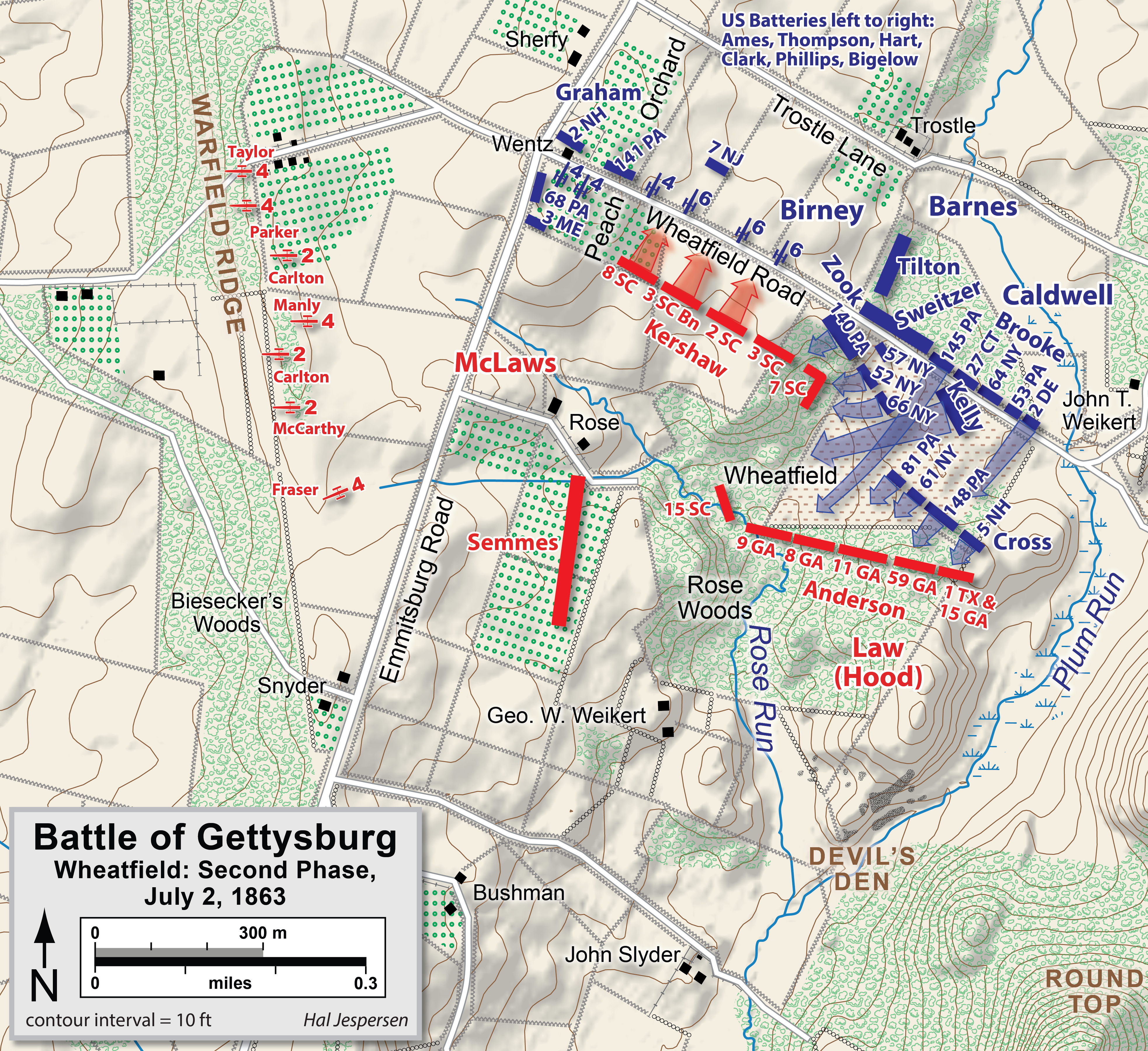
| Beskrivelse | Map of Wheatfield actions in the Battle of Gettysburg, Second Day, of the American Civil War. Updated unit positions and made topographical background consistent with many other Wikipedia Gettysburg maps. Drawn in Adobe Illustrator CS5 by Hal Jespersen. Graphic source file is available at http://www.posix.com/CWmaps/ |
| Dato | |
| Kilde | Eget arbejde |
| Forfatter | Hal Jespersen |
Denne fil er licenseret under Creative Commons Navngivelse 3.0 Unported-licensen.
Kreditering: Map by Hal Jespersen, www.posix.com/CW
- Du må frit:
- at dele – at kopiere, distribuere og overføre værket
- at remixe – at tilpasse værket
- Under følgende vilkår:
- kreditering – Du skal give passende kreditering, angive et link til licensen, og oplyse om der er foretaget ændringer. Du må gøre det på enhver fornuftig måde, men ikke på en måde der antyder at licensgiveren godkender dig eller din anvendelse.
Filhistorik
Klik på en dato/tid for at se filen som den så ud på det tidspunkt.
| Dato/tid | Miniaturebillede | Dimensioner | Bruger | Kommentar | |
|---|---|---|---|---|---|
| nuværende | 3. feb. 2023, 19:40 | | 3.931 × 3.600 (7,35 MB) | Hlj | improved graphics and detail; now second in series of 4 Wheatfield maps |
| 6. jan. 2012, 18:25 |  | 2.449 × 1.789 (1,31 MB) | Hlj | Corrected a unit name. Same license. | |
| 2. apr. 2011, 22:04 |  | 2.449 × 1.789 (1,12 MB) | Hlj | Updated graphical format of rivers and roads. Same license. | |
| 31. jul. 2010, 02:04 |  | 2.449 × 1.789 (1,08 MB) | Hlj | New version improves accuracy of unit positions and graphic style that matches others in the Gettysburg series. Added legend box. Drawn by Hal Jespersen in Adobe Illustrator CS5. Graphic source file is available at http://www.posix.com/CWmaps/ {{cc-by-3.0 | |
| 10. jul. 2010, 20:34 |  | 2.449 × 1.789 (1,08 MB) | Hlj | {{Information |Description=Map of Little Round Top (Battle of Gettysburg) of the American Civil War. Updated unit positions and made topographical background consistent with many other Wikipedia Gettysburg maps. Drawn in Adobe Illustrator CS5 by Hal J | |
| 16. nov. 2006, 17:52 |  | 1.136 × 1.180 (362 KB) | Rheo1905~commonswiki | This map is made by en:User:Hlj. 1863. 7. 2. Gettysburg Second Day, Battle of Wheatfield (1) {{PD-release}} |
Filanvendelse
Den følgende side bruger denne fil:
Global filanvendelse
Følgende andre wikier anvender denne fil:
- Anvendelser på cs.wikipedia.org
- Anvendelser på en.wikipedia.org
- Anvendelser på hu.wikipedia.org
- Anvendelser på ko.wikipedia.org
- Anvendelser på zh.wikipedia.org