
Fil:GrahamLandstubmap.png
Der findes ingen højere opløsning af billedet
GrahamLandstubmap.png (243 × 334 billedpunkter, filstørrelse: 30 KB, MIME-type: image/png)
|
|
Denne fil er fra Wikimedia Commons. Beskrivelsen af filen fra Commons er gengivet nedenfor. |
Beskrivelse
| Beskrivelse |
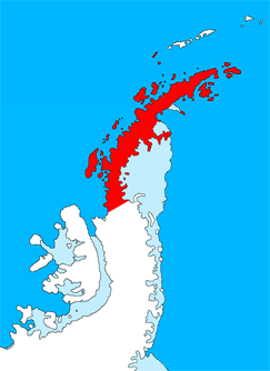
English: Outline map of the Antarctic Peninsula showing Graham Land.
Drawn by me (User:Grutness) based on File:Ant-pen_map.png by Giovanni Fattori. |
| Dato | 2. juli 2011 (original upload date) |
| Kilde | Transferred from en.wikipedia to Commons. |
| Forfatter | The original uploader was Grutness at engelsk Wikipedia. |
Licensering

|
Tilladelse er givet til at kopiere, distribuere og/eller ændre dette dokument under betingelserne i GNU Free Documentation License', Version 1.2 eller enhver senere version udgivet af Free Software Foundation; uden et invariant afsnit, ingen forsidetekster, og ingen bagsidetekst. En kopi af licensen er inkluderet i afsnittet GNU Free Documentation License. |
Oprindelig oplægningslog
The original description page was here. All following user names refer to en.wikipedia.
- 2011-07-02 09:38 Grutness 243×334× (30925 bytes) Outline map of the Antarctic Peninsula showing [[Graham Land]]. Drawn by me (User:Grutness) based on [[:File:Ant-pen_map.png]] by Giovanni Fattori.{{GFDL}}
Filhistorik
Klik på en dato/tid for at se filen som den så ud på det tidspunkt.
| Dato/tid | Miniaturebillede | Dimensioner | Bruger | Kommentar | |
|---|---|---|---|---|---|
| nuværende | 9. jul. 2011, 22:06 | | 243 × 334 (30 KB) | MGA73bot2 | {{BotMoveToCommons|en.wikipedia|year={{subst:CURRENTYEAR}}|month={{subst:CURRENTMONTHNAME}}|day={{subst:CURRENTDAY}}}} {{Information |Description={{en|Outline map of the Antarctic Peninsula showing en:Graham Land. Drawn by me (User:Grutness) base |
Filanvendelse
Den følgende side bruger denne fil:
Global filanvendelse
Følgende andre wikier anvender denne fil:
- Anvendelser på az.wikipedia.org
- Anvendelser på bg.wikipedia.org
- Anvendelser på cs.wikipedia.org
- Anvendelser på de.wikipedia.org
- Anvendelser på en.wikipedia.org
- Mount Scott (Antarctica)
- Bowman Coast
- Bearing Island
- Enterprise Island
- Cuverville Island
- Danco Island
- Reclus Peninsula
- Charlotte Bay
- Loubet Coast
- Rongé Island
- Mill Inlet
- Cabinet Inlet
- Cape Alexander
- Cole Peninsula
- Hughes Bay
- Castle Peak (Antarctica)
- Quartermain Glacier
- Quervain Peak
- Aagaard Glacier
- Leonardo Glacier
- Bigourdan Fjord
- Cape Jeremy
- Weertman Island
- Bennett Islands
- Liard Island
- Arctowski Peninsula
- Devil Island
- Upper Island
- Useful Island
- Mount Zdarsky
- Mount Shackleton
- Shag Rock (Antarctica)
- Shanty Point
- Sharp Glacier
- Mount Shelby
- Mount St. Louis
- Short Island
- Shull Rocks
- Sikorsky Glacier
Vis flere globale anvendelser af denne fil.