
Fil:Greece in 1210.svg

Size of this PNG preview of this SVG file: 800 × 456 pixels. Andre opløsninger: 320 × 182 pixels | 640 × 365 pixels | 1.024 × 584 pixels | 1.280 × 730 pixels | 2.560 × 1.460 pixels | 3.508 × 2.000 pixels.
Fuld opløsning (SVG fil, basisstørrelse 3.508 × 2.000 pixels, filstørrelse: 1,12 MB)
|
|
Denne fil er fra Wikimedia Commons. Beskrivelsen af filen fra Commons er gengivet nedenfor. |
Beskrivelse
| Beskrivelse |
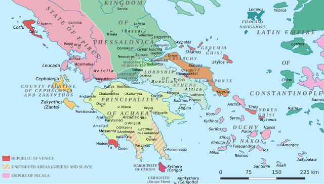
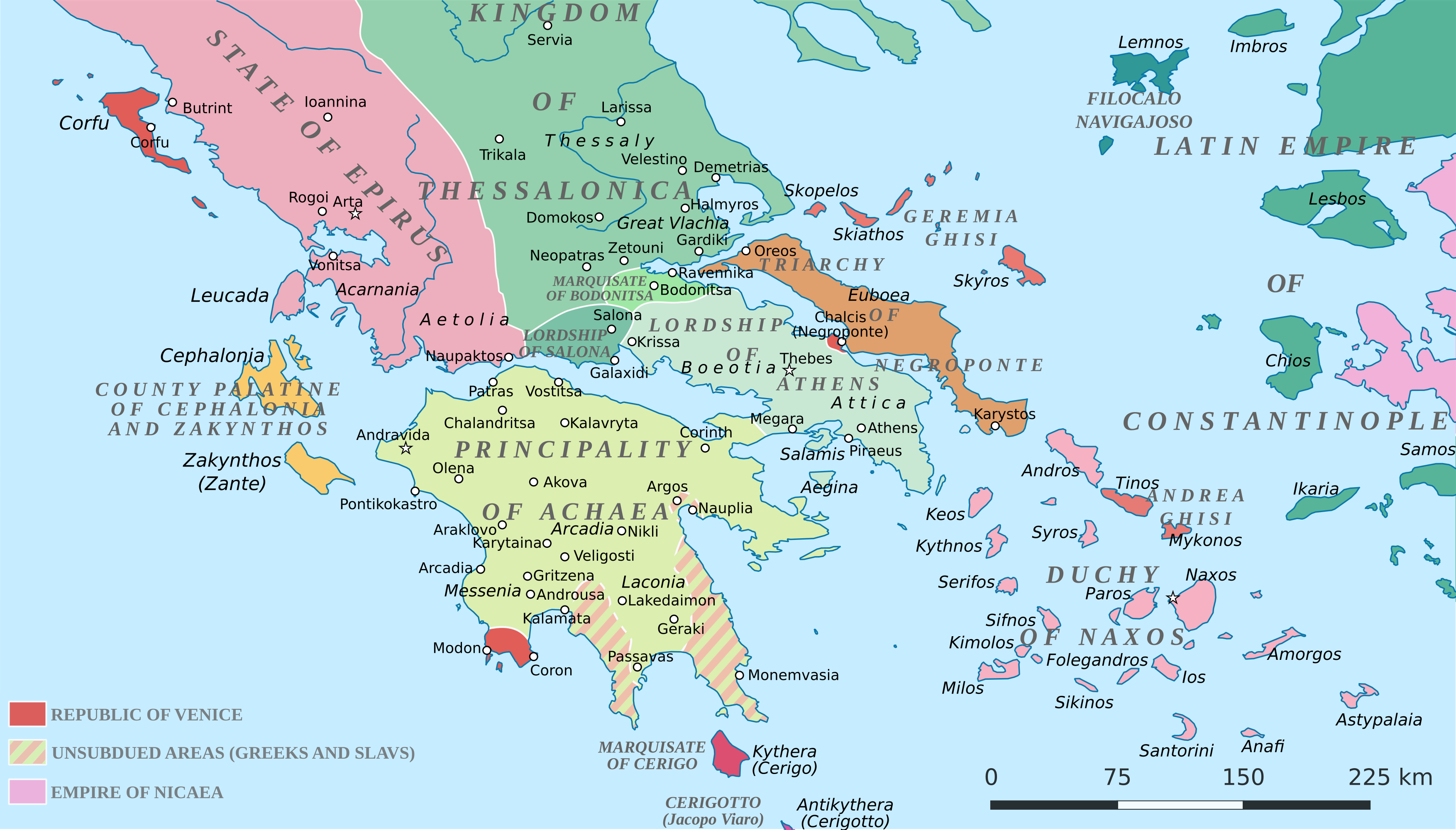
English: Political map of southern Greece in c. 1210, after the establishment of the Crusader states following the Fourth Crusade. |
| Dato | |
| Kilde |
SVG base from File:Greece in 1210V1.svg; based on the original political map by William Miller (1908), with changes and corrections to account for newer scholarship:
|
| Forfatter | Cplakidas |
| Andre versioner |
|


Licensering
Jeg, dette værks ophavsretsindehaver, publicerer hermed værket under den følgende licens:
This file is licensed under the Creative Commons Attribution-Share Alike 4.0 International license.
- Du må frit:
- at dele – at kopiere, distribuere og overføre værket
- at remixe – at tilpasse værket
- Under følgende vilkår:
- kreditering – Du skal give passende kreditering, angive et link til licensen, og oplyse om der er foretaget ændringer. Du må gøre det på enhver fornuftig måde, men ikke på en måde der antyder at licensgiveren godkender dig eller din anvendelse.
- deling på samme vilkår – Hvis du bearbejder, ændrer eller bygger videre på dette værk, skal du distribuere dine bidrag under den samme eller en kompatibel licens som originalen.
Filhistorik
Klik på en dato/tid for at se filen som den så ud på det tidspunkt.
| Dato/tid | Miniaturebillede | Dimensioner | Bruger | Kommentar | |
|---|---|---|---|---|---|
| nuværende | 23. jun. 2017, 21:59 | | 3.508 × 2.000 (1,12 MB) | Cplakidas | fixed three names to paths |
| 11. apr. 2017, 14:08 |  | 3.508 × 2.000 (1,1 MB) | Cplakidas | colour changes | |
| 11. apr. 2017, 13:48 |  | 3.508 × 2.000 (1,11 MB) | Cplakidas | tweak around Coron | |
| 11. feb. 2017, 12:39 |  | 3.508 × 2.000 (1,11 MB) | Cplakidas | tweaks in Negroponte, unsubdued areas | |
| 8. feb. 2017, 19:57 |  | 3.508 × 2.000 (1,11 MB) | Cplakidas | tweaking the Morea | |
| 8. feb. 2017, 15:40 |  | 3.508 × 2.000 (1,11 MB) | Cplakidas | slight tweaks | |
| 8. feb. 2017, 15:14 |  | 3.508 × 2.000 (1,11 MB) | Cplakidas | User created page with UploadWizard |
Filanvendelse
Den følgende side bruger denne fil:
Global filanvendelse
Følgende andre wikier anvender denne fil:
- Anvendelser på ar.wikipedia.org
- Anvendelser på az.wikipedia.org
- Anvendelser på bg.wikipedia.org
- Anvendelser på ca.wikipedia.org
- Anvendelser på de.wikipedia.org
- Anvendelser på el.wikipedia.org
- Anvendelser på en.wikipedia.org
- Anvendelser på eo.wikipedia.org
- Anvendelser på eu.wikipedia.org
- Anvendelser på fa.wikipedia.org
- Anvendelser på fr.wikipedia.org
- Anvendelser på gl.wikipedia.org
- Anvendelser på hr.wikipedia.org
- Anvendelser på id.wikipedia.org
- Anvendelser på it.wikipedia.org
- Anvendelser på ja.wikipedia.org
- Anvendelser på ko.wikipedia.org
- Anvendelser på ro.wikipedia.org
- Anvendelser på ru.wikipedia.org
- Anvendelser på sk.wikipedia.org
- Anvendelser på sr.wikipedia.org
Vis flere globale anvendelser af denne fil.