
Fil:Luke Foxe voyage account (North-West Fox, 1635) - 2 foldout map -1 full view.png

Fuld opløsning (5.742 × 4.226 billedpunkter, filstørrelse: 39,96 MB, MIME-type: image/png)
|
|
Denne fil er fra Wikimedia Commons. Beskrivelsen af filen fra Commons er gengivet nedenfor. |
Beskrivelse
| Beskrivelse |
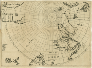
English: Fold-out engraved map from Luke Foxe's voyage account book, showing the route of his 1631 sea expedition from England (top right) in search of a Northwest passage towards Asia (top left) through Hudson Strait, exploring Hudson Bay and Foxe Basin (detail). The map uses the azimuthal equidistant projection, with the North Pole as its center point. At bottom left, near the Island of California, the map is decorated with a fox, the author's emblem.
|
||||||||||||||||||||
| Dato | |||||||||||||||||||||
| Kilde |
Courtesy of John Carter Brown Library at Brown University
|
||||||||||||||||||||
| Skaber |
|
||||||||||||||||||||
| Tilladelse (Genbrug af denne fil) |
|
||||||||||||||||||||
| Geotemporal data | |||||||||||||||||||||
| Dato afbildet | |||||||||||||||||||||
| Map location | Hudson Bay, Hudson Strait, Baffin Bay, Arctic Canada, Greenland | ||||||||||||||||||||
| Map type | nautical chart | ||||||||||||||||||||
| Spatial reference system | azimuthal equidistant centered on North Pole | ||||||||||||||||||||
| Bounding box |
|
||||||||||||||||||||
| Bibliographic data | |||||||||||||||||||||
| Publikation | |||||||||||||||||||||
| Side(r) | fold-out map following p. 172 | ||||||||||||||||||||
| Sprog | engelsk | ||||||||||||||||||||
| Udgivelsessted | London | ||||||||||||||||||||
| Trykt af |
B. Alsop,
|
||||||||||||||||||||
| Archival data | |||||||||||||||||||||
| Samling |
|
||||||||||||||||||||
| Museumsnummer |
29912 |
||||||||||||||||||||
| Mål | højde: 31,7 cm; bredde: 44 cm | ||||||||||||||||||||
| Teknik | gravering | ||||||||||||||||||||
| artwork-references |
|
||||||||||||||||||||
| Scan resolution | 96 dpi | ||||||||||||||||||||
| Andre versioner |
|
||||||||||||||||||||
.svg)


_-_3_foldout_map_-_2_Hudson_Bay.png)
_-_4_foldout_map_-_3_fox.png)
_-_2_foldout_map_-1_full_view.png?uselang=da)
Filhistorik
Klik på en dato/tid for at se filen som den så ud på det tidspunkt.
| Dato/tid | Miniaturebillede | Dimensioner | Bruger | Kommentar | |
|---|---|---|---|---|---|
| nuværende | 28. mar. 2021, 22:56 | | 5.742 × 4.226 (39,96 MB) | Wikipetzi | {{Map |description = {{en |1= Fold-out engraved map from {{w|Luke Foxe|Luke Foxe}}'s voyage account book, showing the route of his 1631 sea expedition from England (top right) in search of a Northwest passage towards Asia (top left) through Hudson Strait, exploring Hudson Bay and Foxe Basin. The map uses the {{w|Azimuthal equidistant projection|azimuthal equidistant projection}}, with the North Pole as its center point. At bottom left, near the {{w|Island of California|Island of Califo... |
Filanvendelse
Der er ingen sider der bruger denne fil.
Global filanvendelse
Følgende andre wikier anvender denne fil:
- Anvendelser på en.wikipedia.org
_-_2_foldout_map_-1_full_view.png)