
Fil:MANCHURIA-U.S.S.R BOUNDARY Ct002999.jpg
Størrelse af denne forhåndsvisning: 784 × 599 pixels. Andre opløsninger: 314 × 240 pixels | 628 × 480 pixels | 1.005 × 768 pixels | 1.280 × 978 pixels | 2.560 × 1.957 pixels | 4.167 × 3.185 pixels.
Fuld opløsning (4.167 × 3.185 billedpunkter, filstørrelse: 4,25 MB, MIME-type: image/jpeg)
|
|
Denne fil er fra Wikimedia Commons. Beskrivelsen af filen fra Commons er gengivet nedenfor. |
Beskrivelse
| Beskrivelse |
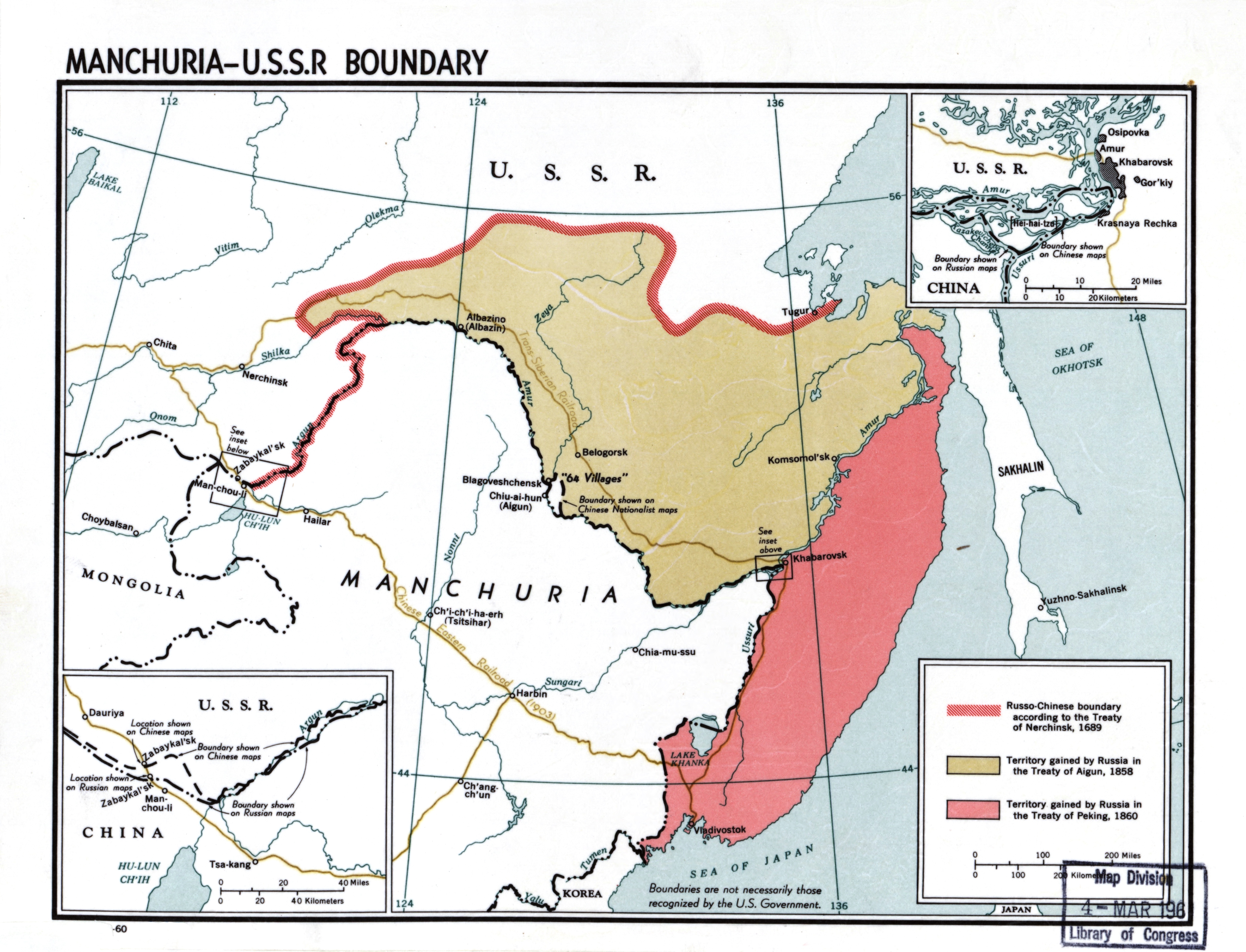
English: Manchuria-U.S.S.R. boundary |
| Dato | |
| Kilde |
Library of Congress Geography and Map Division Washington, D.C. 20540-4650 USA DIGITAL ID g7822m ct002999 http://hdl.loc.gov/loc.gmd/g7822m.ct002999 |
| Forfatter | CIA |
Licensering
| This image is a work of a Central Intelligence Agency employee, taken or made as part of that person's official duties. As a Work of the United States Government, this image or media is in the public domain in the United States.
|

|
Filhistorik
Klik på en dato/tid for at se filen som den så ud på det tidspunkt.
| Dato/tid | Miniaturebillede | Dimensioner | Bruger | Kommentar | |
|---|---|---|---|---|---|
| nuværende | 23. nov. 2020, 22:50 | | 4.167 × 3.185 (4,25 MB) | Gryffindor | {{Information |Description= |Source= |Date= |Author= |Permission= |other_versions= }} |
| 22. feb. 2014, 16:53 |  | 4.167 × 3.185 (6,22 MB) | Viktoria Kunst | User created page with UploadWizard |
Filanvendelse
Den følgende side bruger denne fil:
Global filanvendelse
Følgende andre wikier anvender denne fil:
- Anvendelser på af.wikipedia.org
- Anvendelser på ar.wikipedia.org
- Anvendelser på az.wikipedia.org
- Anvendelser på bn.wikipedia.org
- Anvendelser på ca.wikipedia.org
- Anvendelser på ckb.wikipedia.org
- Anvendelser på cs.wikipedia.org
- Anvendelser på de.wikipedia.org
- Anvendelser på en.wikipedia.org
- Manchuria
- History of Manchuria
- Treaty of Aigun
- Treaty of Nerchinsk
- Outer Manchuria
- Territorial evolution of Russia
- Sixty-Four Villages East of the River
- Bolshoy Ussuriysky Island
- Sino-Russian border conflicts
- Amur Annexation
- China–Russia relations
- China–Russia border
- Russia in the Opium Wars
- Timeline of the Qing dynasty
- User:Falcaorib
- Soviet deportations of Chinese people
- User:HNlander/Deportation of Chinese in the Soviet Union
- Anvendelser på en.wiktionary.org
- Anvendelser på es.wikipedia.org
- Anvendelser på fa.wikipedia.org
- Anvendelser på fi.wikipedia.org
- Anvendelser på fr.wikipedia.org
Vis flere globale anvendelser af denne fil.