
Fil:Map of Transcontiental nations.png

Størrelse af denne forhåndsvisning: 800 × 351 pixels. Andre opløsninger: 320 × 140 pixels | 640 × 281 pixels | 1.425 × 625 pixels.
Fuld opløsning (1.425 × 625 billedpunkter, filstørrelse: 40 KB, MIME-type: image/png)
|
|
Denne fil er fra Wikimedia Commons. Beskrivelsen af filen fra Commons er gengivet nedenfor. |
Misspelt title of map: Transcontiental>Transcontinental
Only two shades of blue distinguishable.
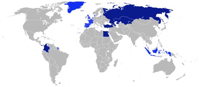
Beskrivelse
| Beskrivelse |
Afrikaans: Kaart van Transkontinentale nasies.
state met 'n aangrensende grens
state met 'n nie-aangrensende grens
state met 'n gebied wat transkontinentale Dansk: Kort over transkontinentale nationer.
stater med en sammenhængende grænse.
stater med en ikke-sammenhængende grænse.
stater med et område, der er transkontinentale. English: Map of transcontinental nations.
states with a contiguous boundary.
states with a non-contiguous boundary.
states with a territory that's transcontinental. Español: Mapa de las naciones transcontinental.
estados con un límite contigua.
estados con un límite no contigua.
Estados con un área de Transcontinental. Français : Carte des pays transcontinentaux.
pays ayant une continuité territoriale de ses frontières.
pays sans continuité territoriale de ses frontières.
pays ayant un territoire transcontinental. Nederlands: Kaart van Transcontinentale naties.
staten met een aangrenzende grens.
staten met een niet-aangrenzende grens.
staten met een gebied dat transcontinentaal is. Türkçe: Kıtalararası Ülkeler.
Bitişik sınır ülkeleri.
Sınırı bitişik olmayan ülkeler.
Denizaşırı toprağı bulunan ülkeler. Русский: Карта Трансконтинентальных стран.
Государства с примыкающей границей.
Государства с несмежной границей.
Государства с Трансконтинентальной площадью. العربية : خريطة الدول عابرة للقارات.
الدول التي لها حدود متماسك.
الدول التي لها حدود غير متجاورة.
الدول التي لديها أراضي هذا هو عابر للقارات. |
| Dato | |
| Kilde | Eget arbejde |
| Forfatter | $200inaire |
Licensering
Jeg, dette værks ophavsretsindehaver, publicerer hermed værket under den følgende licens:
Denne fil er udgivet under Creative Commons Kreditering-Del på samme vilkår 3.0 Ikke-porteret-licensen.
- Du må frit:
- at dele – at kopiere, distribuere og overføre værket
- at remixe – at tilpasse værket
- Under følgende vilkår:
- kreditering – Du skal give passende kreditering, angive et link til licensen, og oplyse om der er foretaget ændringer. Du må gøre det på enhver fornuftig måde, men ikke på en måde der antyder at licensgiveren godkender dig eller din anvendelse.
- deling på samme vilkår – Hvis du bearbejder, ændrer eller bygger videre på dette værk, skal du distribuere dine bidrag under den samme eller en kompatibel licens som originalen.
Filhistorik
Klik på en dato/tid for at se filen som den så ud på det tidspunkt.
| Dato/tid | Miniaturebillede | Dimensioner | Bruger | Kommentar | |
|---|---|---|---|---|---|
| nuværende | 4. aug. 2014, 21:41 | | 1.425 × 625 (40 KB) | KronosLine | Added South Sudan, removed Kosovo (either include all breakaway regions or none) |
| 5. apr. 2014, 12:32 |  | 1.425 × 625 (33 KB) | SeeSchloss | Added French overseas territories (French Guyana, Southern territories, St Pierre & Miquelon, Guadeloupe, Martinique, Réunion, Mayotte, New Caledonia, Wallis & Futuna - I couldn't spot French Polynesia islands on the map) as well as Corsica. Added Spa... | |
| 25. feb. 2014, 06:09 |  | 1.425 × 625 (40 KB) | Scoelho86 | +POR | |
| 31. jan. 2014, 06:33 |  | 1.425 × 625 (40 KB) | Scoelho86 | +COL | |
| 13. jun. 2012, 09:48 |  | 1.425 × 625 (57 KB) | $200inaire | Fix some errors and flaws in the map | |
| 11. jun. 2012, 01:16 |  | 1.425 × 625 (56 KB) | $200inaire |
Filanvendelse
Den følgende side bruger denne fil:
Global filanvendelse
Følgende andre wikier anvender denne fil:
- Anvendelser på arz.wikipedia.org
- Anvendelser på la.wikipedia.org
- Anvendelser på ml.wikipedia.org