
Fil:Nauru map.jpg

Størrelse af denne forhåndsvisning: 484 × 600 pixels. Andre opløsninger: 194 × 240 pixels | 387 × 480 pixels | 994 × 1.232 pixels.
Fuld opløsning (994 × 1.232 billedpunkter, filstørrelse: 128 KB, MIME-type: image/jpeg)
|
|
Denne fil er fra Wikimedia Commons. Beskrivelsen af filen fra Commons er gengivet nedenfor. |
|

|
Dette billede (eller alle billederne i denne artikel eller kategori) bør genskabes ved hjælp af vektorgrafik som en SVG-fil. Dette har flere fordele; se Commons:Media for cleanup for mere information. Hvis der eksisterer en SVG-version af dette billede, så vær venlig at lægge den op. Efter en SVG-version er blevet lagt op, så erstat denne skabelon med {{Vector version available|nyt billedes navn.svg}} på denne side.
|


Beskrivelse
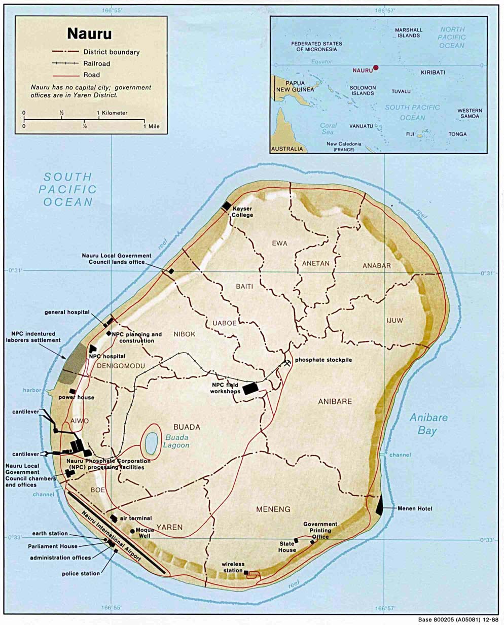
| Beskrivelse | Small-label map of the island of Nauru (click image to enlarge for reading labels), northeast of Australia, north of the Solomon Islands and northwest of Fiji. The island is surrounded by a coral reef ring. The map shows some detailed contour areas near the shoreline. |
| Dato | |
| Kilde | Nauru (Shaded Relief) 1988 from Library Map Collection: Maps of Australia and the Pacific |
| Forfatter | U.S. Central Intelligence Agency |
| Tilladelse (Genbrug af denne fil) |
Public domain |
| Andre versioner |
Same map with larger labels: Image:Nauru_map_bold.jpg (has larger labels of nearby areas, the oceans, and district names). |
Licensering
| This image is a work of a Central Intelligence Agency employee, taken or made as part of that person's official duties. As a Work of the United States Government, this image or media is in the public domain in the United States.
|

|
Filhistorik
Klik på en dato/tid for at se filen som den så ud på det tidspunkt.
| Dato/tid | Miniaturebillede | Dimensioner | Bruger | Kommentar | |
|---|---|---|---|---|---|
| nuværende | 27. mar. 2005, 01:48 | | 994 × 1.232 (128 KB) | Jon Harald Søby | From the English Wikipedia. {{PD-USGov}} |
Filanvendelse
Der er ingen sider der bruger denne fil.
Global filanvendelse
Følgende andre wikier anvender denne fil:
- Anvendelser på azb.wikipedia.org
- Anvendelser på bg.wikipedia.org
- Anvendelser på en.wikipedia.org
- Anvendelser på he.wikipedia.org
- נאורו
- תבנית:הידעת? 11 באפריל - סדרה 2
- ויקיפדיה:הידעת?/2014/יולי
- תבנית:הידעת? 11 ביולי 2014
- ויקיפדיה:הידעת?/2016/אפריל
- תבנית:הידעת? 14 באפריל 2016
- ויקיפדיה:הידעת?/2018/אפריל
- תבנית:הידעת? 10 באפריל 2018
- ויקיפדיה:הידעת?/2020/אפריל
- תבנית:הידעת? 11 באפריל 2020
- פורטל:מדע המדינה/הידעת?/קטעי הידעת?
- פורטל:מדע המדינה/הידעת?/16
- פורטל:מדעי החברה/הידעת?/קטעי הידעת?
- פורטל:מדעי החברה/הידעת?/79
- ויקיפדיה:הידעת?/2023/אפריל
- תבנית:הידעת? 11 באפריל 2023
- Anvendelser på id.wikipedia.org
- Anvendelser på incubator.wikimedia.org
- Anvendelser på ja.wikipedia.org
- Anvendelser på jv.wikipedia.org
- Anvendelser på ka.wikipedia.org
- Anvendelser på ms.wikipedia.org
- Anvendelser på sv.wikipedia.org
- Anvendelser på uk.wikipedia.org