
Fil:Otoe Tribal Seal.jpg
Otoe_Tribal_Seal.jpg (300 × 300 billedpunkter, filstørrelse: 60 KB, MIME-type: image/jpeg)
|
|
Denne fil er fra Wikimedia Commons. Beskrivelsen af filen fra Commons er gengivet nedenfor. |
|

|
Dette billede (eller alle billederne i denne artikel eller kategori) bør genskabes ved hjælp af vektorgrafik som en SVG-fil. Dette har flere fordele; se Commons:Media for cleanup for mere information. Hvis der eksisterer en SVG-version af dette billede, så vær venlig at lægge den op. Efter en SVG-version er blevet lagt op, så erstat denne skabelon med {{Vector version available|nyt billedes navn.svg}} på denne side.
|


Beskrivelse
| Beskrivelse |
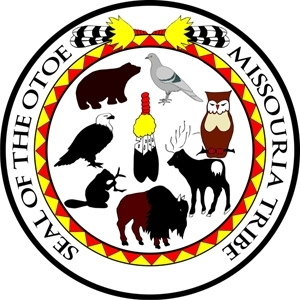
LOCATION AND LAND STATUS: The Otoe-Missouria Reservation is located on the plains of north-central Oklahoma, just south of the Salt Fork of the Arkansas River. Otoe-Missouria Tribal Jurisdiction Lands include some 20,576.23 acres of non-contiguous trust and non-trust properties within Noble County, Oklahoma. The town of Red Rock, Oklahoma serves as the tribal headquarters. The Otoe-Missouria Reservation is accessible via east-west running State Highway 15 which intersects Red Rock; the reservation is also serviced by north-south running U.S. Highway 177. Incorporated Oklahoma towns near the reservation include Red Rock, Ceres, Perry, and Marland. Major Oklahoma cities near the reservation include Ponca City (16 miles north), Stillwater (27 miles south), Tulsa (100 miles east), and Oklahoma City (100 miles southwest). In 1881, the federal government established a reservation for the Otoe and Missouria Tribes within the Cherokee Outlet in Indian Territory. By 1883, most tribal members were relocated to the area of the present-day reservation. The entire reservation was allotted to tribal members in 1904. Today, tribal trust and allotted lands are interspersed with some 61,920 non-Indian parcels within the reservation’s boundaries. CULTURE AND HISTORY: The American Indians remain probably the least understood and most misunderstood American of all. American Indians defy any single description. They were and are far too invidualistic, they share no common language and few common customs. But collectively their history is our history and should be part of our shared and remembered heritage. The Otoe and Missouria Tribe of the Siouxian stock. The Plans Indians were composed of tribes that were offsprings of the Dakota (Sioux) Tribe. The Otoe tribe once inhabited an area west of Lake Michigan in the area of the present states of Minnesota and Wisconsin. The Winnebage Tribe also lived in the area and therefore their languages are similar. The Otoes eventually occupied an area in Iowa and later in Southeastern Nebraska along the Platte River. The Kansa (Kaw), Omaha, Ponca, Pawnee, and Iowa Tribes lived in the same area during this period of time. They are still our neighbors today. The tribe gave the amrea the name Ne-bhla-ska, flat or broad water. We know this today as the state of Nebraska. The Missouri Tribe gave their name to a great river and state, Missouri. The tribe Neu-dache (drown in water) and the Otoe Gee-Wa-Lhe Tribe merged in the early 1670s. Both tribes were small at this time and numbered approximately 1500. Their languages were slightly different but time has made them as one. If mention is made of the tribe as Otoe it is in reference to both tribes. From 1757 on, these tribes lived in Nebraska and were identified as prairie dwellers. There are 1460 members enrolled on the current Tribal Roll. Applicants and members possess 1/4 or more Otoe and Missouri Tribal Blood. The Otoe and Missouria Tribes were not known to be warlike but as a friendly and peaceful people. During the 1870s white settlers, politicians, representatives, and sometimes Indian Agency officials were busy on plans to remove these and other tribes to Indian Territory in 1881 on October 5 and arrived on October 23. The tribe was not happy to leave the fertile bottom lands of the Little and Big Blue Rivers, Republican and Nemaha Rivers but the move was made peacefully and orderly by the tribe. The site where we now hold our Annual Summer Encampment is the approximate area where the horse-drawn wagons and personal belongings of thepeople completed their journey. At one time there were more clans in the social structure of the tribe there are only seven which exist today. EAGLE, OWL, PIGEON, BUFFALO, BEAVER, BEAR, AND ELK. Clan membership is acquired by the offsprings through the fathers side. In the even of a non-Indian father the children follow themother and her clan affiliation. Tribal ceremonies which are still practices today, but not extensively, are the tribal funderals and feasts, giving of Indian names by elders and prominent leaders to children, honoring of friendship between tribal members which were formed by elders and praents of the families concerned, the initiation of young dancers who are appearing publicly in costume for the first time. This is a ceremony which most youngsters experienceduring the summer encampment dances. The Eloska Society is active in tribal activities. Their membership is made up of men who served in wars and are revered and respected as Warriors. Approximately 10 percent of the tribal membership has served in the Armed Forces of our country during all wars. The organization which the tribe holds high regard and respect for is the patriotic Otoe War Mothers. his was the first tribal organization of Indian Mothers tobe chartered nationally. The War Mothers are an active group and perform many worthy projects and veterans of all races are appreciative for their services. GOVERNMENT: The Otoe-Missouria Reservation is governed by a tribal council. Tribal government is divided into numerous sectors including a Tribal Court, Tribal Tax Commission, Tribal Bingo Commission, Tribal Law Enforcement, Tribal Education Services, Tribal Social Services, Tribal Financial Services, Tribal Planner Services, Tribal Asset Management Services, and Tribal Health Services. |
| Dato | |
| Kilde |
|
| Forfatter | Nathan Soliz from Redding, United States |
Licensering
- Du må frit:
- at dele – at kopiere, distribuere og overføre værket
- at remixe – at tilpasse værket
- Under følgende vilkår:
- kreditering – Du skal give passende kreditering, angive et link til licensen, og oplyse om der er foretaget ændringer. Du må gøre det på enhver fornuftig måde, men ikke på en måde der antyder at licensgiveren godkender dig eller din anvendelse.
- deling på samme vilkår – Hvis du bearbejder, ændrer eller bygger videre på dette værk, skal du distribuere dine bidrag under den samme eller en kompatibel licens som originalen.
| Denne medie-fil, der oprindeligt var udgivet på Flickr, blev gennemgået d. November 29, 2010 af administratoren eller den betroede bruger File Upload Bot (Magnus Manske), der har bekræftet at medie-filen p.t. er tilgængelig på Flickr under den ovenstående licens. |
Filhistorik
Klik på en dato/tid for at se filen som den så ud på det tidspunkt.
| Dato/tid | Miniaturebillede | Dimensioner | Bruger | Kommentar | |
|---|---|---|---|---|---|
| nuværende | 29. nov. 2010, 22:07 | | 300 × 300 (60 KB) | File Upload Bot (Magnus Manske) | {{Information |Description=LOCATION AND LAND STATUS: The Otoe-Missouria Reservation is located on the plains of north-central Oklahoma, just south of the Salt Fork of the Arkansas River. Otoe-Missouria Tribal Jurisdiction Lands include some 20,576.23 acr |
Filanvendelse
Den følgende side bruger denne fil:
Global filanvendelse
Følgende andre wikier anvender denne fil:
- Anvendelser på en.wikipedia.org