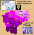
Fil:Stryi and Upper Dneistr Rivers.PNG

Page contents not supported in other languages.
Fra Wikipedia, den frie encyklopædi

Fuld opløsning(631 × 648 billedpunkter, filstørrelse: 63 KB, MIME-type: image/png)


Denne fil er fra Wikimedia Commons

Beskrivelse

Beskrivelse
English: This is a map showing the Upper Dniestr River Basin, including its main tributary, the Stryi River, in the southwestern half of the Lviv Oblast in western Ukraine. It also shows the average annual precipitation by millimeters and inches for the region, and places the administrative centers of each of the raions in this area on the map. It includes and inset indicating where this is in relation to the rest of Ukraine, and provides the names of the closest villages to the Stryi River's head and mouth. I created this map, using Microsoft Paint, version 7.0, and borrowing data from Google Earth, and the 21st European Regional Conference 2005 - 15-19 May 2005 - Frankfurt (Oder) and Slubice - Germany and Poland report on "Floods Modeling in the Upper Dnister River Valley", by Ivan Kovalchuk, Andriy Mykhnovych, Volker Ehlert, Jörg Steidl, in conjunction with the Leibniz Centre for Agricultural Landscape Research (ZALF), Germany, and held at the Ivan Franko National University of L’viv, Ukraine, page4. URL: http://www.zalf.de/icid/ICID_ERC2005/HTML/ERC2005PDF/Topic_2/Kovalchuk.pdf
Dato 10. februar 2010 (original upload date)
Kilde Transferred from en.wikipedia to Commons by SreeBot.
Forfatter Saukkomies at engelsk Wikipedia

Licensering

Public domain Dette værk er blevet udgivet som offentlig ejendom af dets skaber, Saukkomies at engelsk Wikipedia. Dette gælder i hele verden.
I nogle lande er dette ikke juridisk muligt. I så fald:
Saukkomies giver enhver ret til at anvende dette værk til ethvert formål, uden nogen restriktioner, medmindre sådanne restriktioner er påkrævede ved lov.

Oprindelig oplægningslog

The original description page was here. All following user names refer to en.wikipedia.

Upload date | User | Bytes | Dimensions | Comment

  • 2010-02-10 01:12 (UTC) | Saukkomies | 64995 (bytes) | 631×648 | I created this map, using Microsoft Paint, version 7.0, and borrowing data from Google Earth, and the 21st European Regional Conference 2005 - 15-19 May 2005 - Frankfurt (Oder) and Slubice - Germany and Poland report on "Floods Modeling in the Upper Dnist

Captions

Tilføj en kort forklaring på en enkelt linje om hvad filen viser

Elementer som er med i denne fil

afbilder

Filhistorik

Klik på en dato/tid for at se filen som den så ud på det tidspunkt.

Dato/tidMiniaturebilledeDimensionerBrugerKommentar
nuværende18. sep. 2011, 19:36Miniature af versionen fra 18. sep. 2011, 19:36631 × 648 (63 KB)SreeBot(Original text) : I created this map, using Microsoft Paint, version 7.0, and borrowing data from Google Earth, and the 21st European Regional Conference 2005 - 15-19 May 2005 - Frankfurt (Oder) and Slubice - Germany and Poland report on "Floods Modeling

Den følgende side bruger denne fil:

Global filanvendelse

Følgende andre wikier anvender denne fil: