
Fil:The Man in the High Castle Plausible World Map.png
Størrelse af denne forhåndsvisning: 800 × 579 pixels. Andre opløsninger: 320 × 232 pixels | 640 × 463 pixels | 1.024 × 741 pixels | 1.280 × 926 pixels | 1.577 × 1.141 pixels.
Fuld opløsning (1.577 × 1.141 billedpunkter, filstørrelse: 400 KB, MIME-type: image/png)
|
|
Denne fil er fra Wikimedia Commons. Beskrivelsen af filen fra Commons er gengivet nedenfor. |

|
This map, as well as other fictitious maps, is fictitious or too incorrect (i.e. due to anachronism) to be used in real-life contexts (contemporary or historic). It may have some visual elements that are similar to official maps such as colors or certain layout features, but they are NOT official and don't have any official recognition. |
[[Category:]]
Beskrivelse
| Beskrivelse |
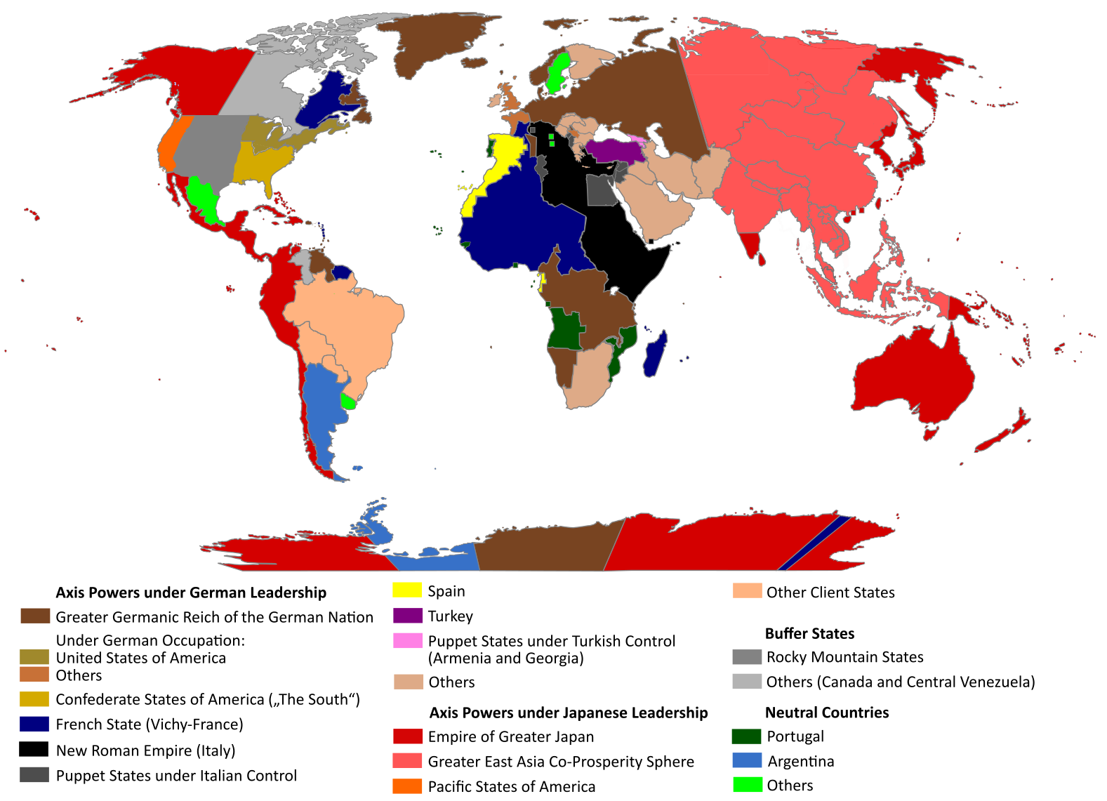
English: "The Man in the High Castle" is an alternate history novel by Philip K. Dick. It is set in a world in which the Axis powers have won World War II. This map is inspired by Dick's story and shows a plausible division of the world between Nazi Germany (dark brown), Imperial Japan (dark red) and their respective allies. However, the map is much more precise than the book describes.
https://web.archive.org/web/20191202005150/http://www.high-castle-world-map.com:80/ |
| Dato | |
| Kilde | Eget arbejde |
| Forfatter | RobintheHighCastle |
| Tilladelse (Genbrug af denne fil) |
Licensering
Jeg, dette værks ophavsretsindehaver, publicerer hermed værket under den følgende licens:
This file is licensed under the Creative Commons Attribution-Share Alike 4.0 International license.
- Du må frit:
- at dele – at kopiere, distribuere og overføre værket
- at remixe – at tilpasse værket
- Under følgende vilkår:
- kreditering – Du skal give passende kreditering, angive et link til licensen, og oplyse om der er foretaget ændringer. Du må gøre det på enhver fornuftig måde, men ikke på en måde der antyder at licensgiveren godkender dig eller din anvendelse.
- deling på samme vilkår – Hvis du bearbejder, ændrer eller bygger videre på dette værk, skal du distribuere dine bidrag under den samme eller en kompatibel licens som originalen.
Filhistorik
Klik på en dato/tid for at se filen som den så ud på det tidspunkt.
| Dato/tid | Miniaturebillede | Dimensioner | Bruger | Kommentar | |
|---|---|---|---|---|---|
| nuværende | 29. okt. 2021, 16:55 | | 1.577 × 1.141 (400 KB) | Saltner67 | Added the portoguese colonies Cabinda and Ajuda since they would still have existed in this world. |
| 20. jun. 2021, 10:05 |  | 1.613 × 1.143 (417 KB) | Gernsback67 | Changed "Greater Asian Co-Prosperity Sphere" in "Greater East Asia Co-Prosperity Sphere", which is correct. | |
| 16. okt. 2020, 17:30 |  | 1.611 × 1.138 (418 KB) | Saltner67 | Restored the latest version. Please do not revert any changes, which have been made to this file so far, without any communication with the author of the map. All changes made here have been initialized by the author and are a result of the same process which has led to the creation of the map in the first place. | |
| 16. okt. 2020, 10:25 |  | 1.621 × 1.137 (392 KB) | Gooduserdude | RV Original research: this image is based on a source and should not be altered | |
| 29. mar. 2020, 16:15 |  | 1.611 × 1.138 (418 KB) | Saltner67 | Improved the accuracy of borders of Mongolia and Manchukuo. | |
| 27. mar. 2020, 17:58 |  | 1.607 × 1.138 (418 KB) | Saltner67 | Enlarged Manchukuo and added the puppet states of Yakutia and Krasnoyarsk/Irkutsk after more research on Kantokuen. | |
| 12. mar. 2020, 21:07 |  | 1.612 × 1.143 (411 KB) | Saltner67 | Moved the Swiss Canton of Valais from Germany to Italy, as has been prepared in the plans for Operation Tannenbaum. | |
| 8. feb. 2020, 20:57 |  | 1.605 × 1.139 (411 KB) | Saltner67 | Reinserted the territories of Tunisia,Greece, Crete and Cyprus after research on the Italian plannings and Greece in WWII. | |
| 21. nov. 2019, 15:21 |  | 1.611 × 1.133 (409 KB) | Gernsback67 | Enlarged Mongolia again after more research on pan-mongolism. | |
| 21. sep. 2019, 17:13 |  | 1.610 × 1.137 (408 KB) | Saltner67 | unified Mongolia, enlarged Manchukuo and Thailand, re-inserted the real-life borders of Laos and Vietnam after research on Demchugdongrub, Kantokuen, Thailand and Indochina in WWII |
Filanvendelse
Den følgende side bruger denne fil:
Global filanvendelse
Følgende andre wikier anvender denne fil:
- Anvendelser på ar.wikipedia.org
- Anvendelser på cs.wikipedia.org
- Anvendelser på de.wikipedia.org
- Anvendelser på en.wikipedia.org
- Anvendelser på en.wikiquote.org
- Anvendelser på es.wikipedia.org
- Anvendelser på gl.wikipedia.org
- Anvendelser på he.wikipedia.org
- Anvendelser på hu.wikipedia.org
- Anvendelser på it.wikipedia.org
- Anvendelser på ja.wikipedia.org
- Anvendelser på ko.wikipedia.org
- Anvendelser på lt.wikipedia.org
- Anvendelser på nl.wikipedia.org
- Anvendelser på pl.wikipedia.org
- Anvendelser på pt.wikipedia.org
- Anvendelser på ro.wikipedia.org
- Anvendelser på ru.wikipedia.org
- Anvendelser på th.wikipedia.org
- Anvendelser på uk.wikipedia.org
- Anvendelser på zh-classical.wikipedia.org
- Anvendelser på zh.wikipedia.org