
Fil:Accreting coast Image6.svg

Size of this PNG preview of this SVG file: 800 × 377 pixels. Andre opløsninger: 320 × 151 pixels | 640 × 301 pixels | 1.024 × 482 pixels | 1.280 × 602 pixels | 2.560 × 1.205 pixels | 1.481 × 697 pixels.
Fuld opløsning (SVG fil, basisstørrelse 1.481 × 697 pixels, filstørrelse: 15 KB)
|
|
Denne fil er fra Wikimedia Commons. Beskrivelsen af filen fra Commons er gengivet nedenfor. |
Beskrivelse
| Beskrivelse |
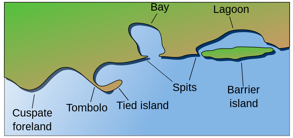
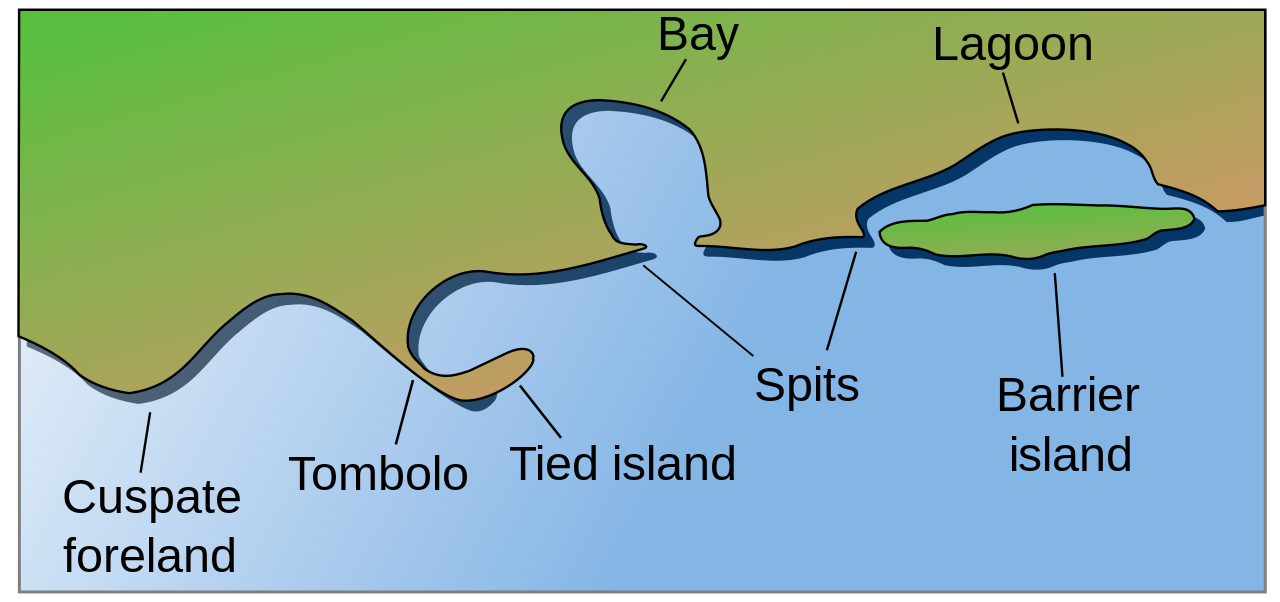
English: Coastal and oceanic landforms. Cuspate foreland, tombolo, spit, bay, lagoon, barrier island. |
| Dato | |
| Kilde | self-made SVG, based on the public domain PNG Accreting coast Image6.png by Feydey |
| Forfatter | Surachit |
| Andre versioner |
Derivative works of this file: Accreting coast Image6-ta.svg
|
| SVG udvikling | Vektorgrafikken blev lavet med Inkscape.
, or with something else. |


Licensering
| Dette værk er blevet udgivet som offentlig ejendom af dets skaber, Feydey. Dette gælder i hele verden. I nogle lande er dette ikke juridisk muligt. I så fald: |
Filhistorik
Klik på en dato/tid for at se filen som den så ud på det tidspunkt.
| Dato/tid | Miniaturebillede | Dimensioner | Bruger | Kommentar | |
|---|---|---|---|---|---|
| nuværende | 16. maj 2022, 06:17 | | 1.481 × 697 (15 KB) | Bacon Noodles | Fixed background (water) alignment |
| 12. feb. 2018, 03:49 |  | 1.481 × 697 (15 KB) | Howpper | Added tied island. A Tombolo is what connects a Tied island to the mainland, so it would be exclusive to not include both features. | |
| 16. aug. 2007, 23:48 |  | 1.481 × 697 (13 KB) | Surachit | {{Information |Description=Coastal and oceanic landforms. Cuspate foreland, tombolo, spit, bay, lagoon, barrier island. |Source=self-made SVG, based on the public domain PNG [http://en.wikipedia.org/wiki/Image:Accreting_coast_Image6.png] by [http://en.wik |
Filanvendelse
Der er ingen sider der bruger denne fil.
Global filanvendelse
Følgende andre wikier anvender denne fil:
- Anvendelser på ar.wikipedia.org
- Anvendelser på az.wikipedia.org
- Anvendelser på bh.wikipedia.org
- Anvendelser på chr.wikipedia.org
- Anvendelser på cs.wikipedia.org
- Anvendelser på en.wikipedia.org
- Archipelago
- Coast
- Dune
- Island
- List of peninsulas
- Beach
- Fjord
- Atoll
- Strait
- Boulder
- Estuary
- Natural arch
- Lagoon
- Coral reef
- Firth
- Isthmus
- Gulf of California
- Coastal erosion
- Talk:Beach
- River delta
- Cliff
- Reef
- Islet
- Salt marsh
- Tombolo
- Stack (geology)
- Cove
- Shoal
- Spit (landform)
- Longshore drift
- Ria
- Barrier island
- Emergent coastline
- Submergent coastline
- Groyne
- Rip current
- Pebble
- Discordant coastline
- Wave-cut platform
Vis flere globale anvendelser af denne fil.