
Fil:Austria-Hungary map-pl.svg

Size of this PNG preview of this SVG file: 776 × 600 pixels. Andre opløsninger: 311 × 240 pixels | 621 × 480 pixels | 994 × 768 pixels | 1.280 × 989 pixels | 2.560 × 1.978 pixels | 783 × 605 pixels.
Fuld opløsning (SVG fil, basisstørrelse 783 × 605 pixels, filstørrelse: 331 KB)
|
|
Denne fil er fra Wikimedia Commons. Beskrivelsen af filen fra Commons er gengivet nedenfor. |
| Beskrivelse |
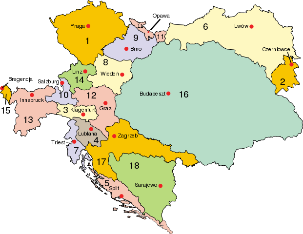
Polski: Austro–Węgry:
Cesarstwo Austrii (Przedlitawia): 1. Czechy, 2. Bukowina, 3. Karyntia, 4. Kraina, 5. Dalmacja, 6. Galicja i Lodomeria, 7. Pobrzeże, 8. Austria przed Anizą, 9. Morawy, 10. Salzburg, 11. Śląsk Austriacki, 12. Styria, 13. Tyrol, 14. Austria za Anizą, 15. Vorarlberg; Królestwo Węgier (Zalitawia): 16. Węgry, 17. Chorwacja; Bośnia: 18. Bośnia i Hercegowina
Deutsch: Österreich-Ungarn 1910:
Cisleithanien: 1. Böhmen, 2. Bukowina, 3. Kärnten, 4. Krain, 5. Dalmatien, 6. Galizien, 7. Küstenland, 8. Österreich unter der Enns, 9. Mähren, 10. Salzburg, 11. Schlesien, 12. Steiermark, 13. Tirol, 14. Österreich ob der Enns, 15. Vorarlberg; Transleithanien: 16. Ungarn, 17. Kroatien und Slawonien; 18. Bosnien und Herzegowina
English: Austria–Hungary:
Empire of Austria (Cisleithania): 1. Bohemia, 2. Bukovina, 3. Carinthia, 4. Carniola, 5. Dalmatia, 6. Galicia, 7. Küstenland, 8. Lower Austria, 9. Moravia, 10. Salzburg, 11. Silesia, 12. Styria, 13. Tyrol, 14. Upper Austria, 15. Vorarlberg; Kingdom of Hungary (Transleithania): 16. Hungary proper 17. Croatia-Slavonia; Austrian-Hungarian Condominium: 18. Bosnia and Herzegovina
Magyar: Ausztria–Magyarország
Osztrák Császárság (Ciszlajtánia): 1. Csehország, 2. Bukovina, 3. Karintia, 4. Krajna, 5. Dalmácia, 6. Galícia, 7. Tengermellék, 8. Alsó-Ausztria, 9. Morvaország, 10. Salzburg, 11. Szilézia, 12. Stájerország, 13. Tirol, 14. Felső-Ausztria, 15. Vorarlberg; Magyar Királyság (Transzlajtánia): 16. Magyarország 17. Horvát-Szlavónország; osztrák–magyar kondomínium: 18. Bosznia és Hercegovina
Latina: Austria-Hungaria: Imperium Austriae (Cisleithania): 1. Bohemia, 2. Bucovina, 3. Carinthia, 4. Carniola, 5. Dalmatia, 6. Galicia, 7. Litorale, 8. Austria Inferior, 9. Moravia, 10. Salisburgum, 11. Silesia, 12. Styria, 13. Tirolis, 14. Austria Superior, 15. Cisarulana; Regnum Hungariae (Transleithania): 16. Hungaria, 17. Croatia et Slavonia Condominium : 18. Bosnia et Herzegovina |
| Dato | |
| Kilde | |
| Forfatter |
|
| Dette er et retoucheret billede, hvilket betyder, at det er blevet digitalt ændret fra sin oprindelige version. Ændringer: translated. Originalen kan ses her: Austria-Hungary map.svg. Ændringer blev udført af Vearthy.
|
Jeg, dette værks ophavsretsindehaver, publicerer hermed værket under den følgende licens:
| |
Dette værk er (allerede eller hermed) frigivet som public domain af sin ophavsretshaver, Example på [[::Forside|engelsk Wikimedia Commons]] projektet. Dette gælder i hele verden. Såfremt lokal lovgivning ikke tillader dette: |
Oprindelig oplægningslog
This image is a derivative work of the following images:
- File:Austria-Hungary_map.svg licensed with PD-user-w
- 2010-04-16T22:48:31Z Vearthy 783x605 (339320 Bytes) changed colours
- 2009-09-14T22:49:21Z Kirk 783x605 (338680 Bytes) english names of capitals
- 2009-09-14T22:41:55Z Kirk 783x605 (338634 Bytes) correctioons
- 2009-08-09T21:00:32Z Gugganij 783x605 (322419 Bytes) Reverted to version as of 19:00, 24 July 2009, reason: the province "Küstenland" was blackened
- 2009-07-25T22:13:52Z Cäsium137 800x640 (280574 Bytes) Valid IDs
- 2009-07-24T23:41:46Z Cäsium137 800x640 (280239 Bytes) smooth
- 2009-07-24T19:00:43Z Hk kng 783x605 (322419 Bytes) a bit of cleanup
- 2009-07-24T18:32:00Z Hk kng 783x605 (326688 Bytes) testing whether using another font helps
- 2009-07-24T09:46:45Z NordNordWest 783x605 (326543 Bytes) Reverted to version as of 05:20, 30 March 2007
- 2009-07-24T09:36:23Z Zsoni 776x600 (2107 Bytes) Korrektur.
- 2007-03-30T05:20:57Z W!B: 783x605 (326543 Bytes) syntax cleanup: groups, named ids, sorted, ..
- 2006-06-28T23:01:58Z Neoneo13 783x605 (243229 Bytes) Taken from english Wikipedia. Created by user IMeowbot {{PD-self}}
Uploaded with derivativeFX
Filhistorik
Klik på en dato/tid for at se filen som den så ud på det tidspunkt.
| Dato/tid | Miniaturebillede | Dimensioner | Bruger | Kommentar | |
|---|---|---|---|---|---|
| nuværende | 17. apr. 2010, 01:27 | | 783 × 605 (331 KB) | Vearthy | {{Information |Description={{en| <br/>'''<u>Austria–Hungary</u>''':<br/>'''Empire of Austria (Cisleithania)''': 1. Bohemia, 2. Bukovina, 3. Carinthia, 4. Carniola, 5. Dalmatia, 6. Galicia, 7. Küstenland, 8. Lower Austria, 9. Moravia, 10. Salzburg, 11. |
Filanvendelse
Der er ingen sider der bruger denne fil.
Global filanvendelse
Følgende andre wikier anvender denne fil:
- Anvendelser på pl.wikipedia.org
- Anvendelser på pl.wiktionary.org
- Anvendelser på uk.wikipedia.org