
Fil:FrontLines Environment Photo Contest Winner -5 (5808476109).jpg
Størrelse af denne forhåndsvisning: 800 × 534 pixels. Andre opløsninger: 320 × 214 pixels | 640 × 427 pixels | 1.024 × 683 pixels | 1.280 × 854 pixels.
Fuld opløsning (1.280 × 854 billedpunkter, filstørrelse: 432 KB, MIME-type: image/jpeg)
|
|
Denne fil er fra Wikimedia Commons. Beskrivelsen af filen fra Commons er gengivet nedenfor. |
.jpg?uselang=da)
Beskrivelse
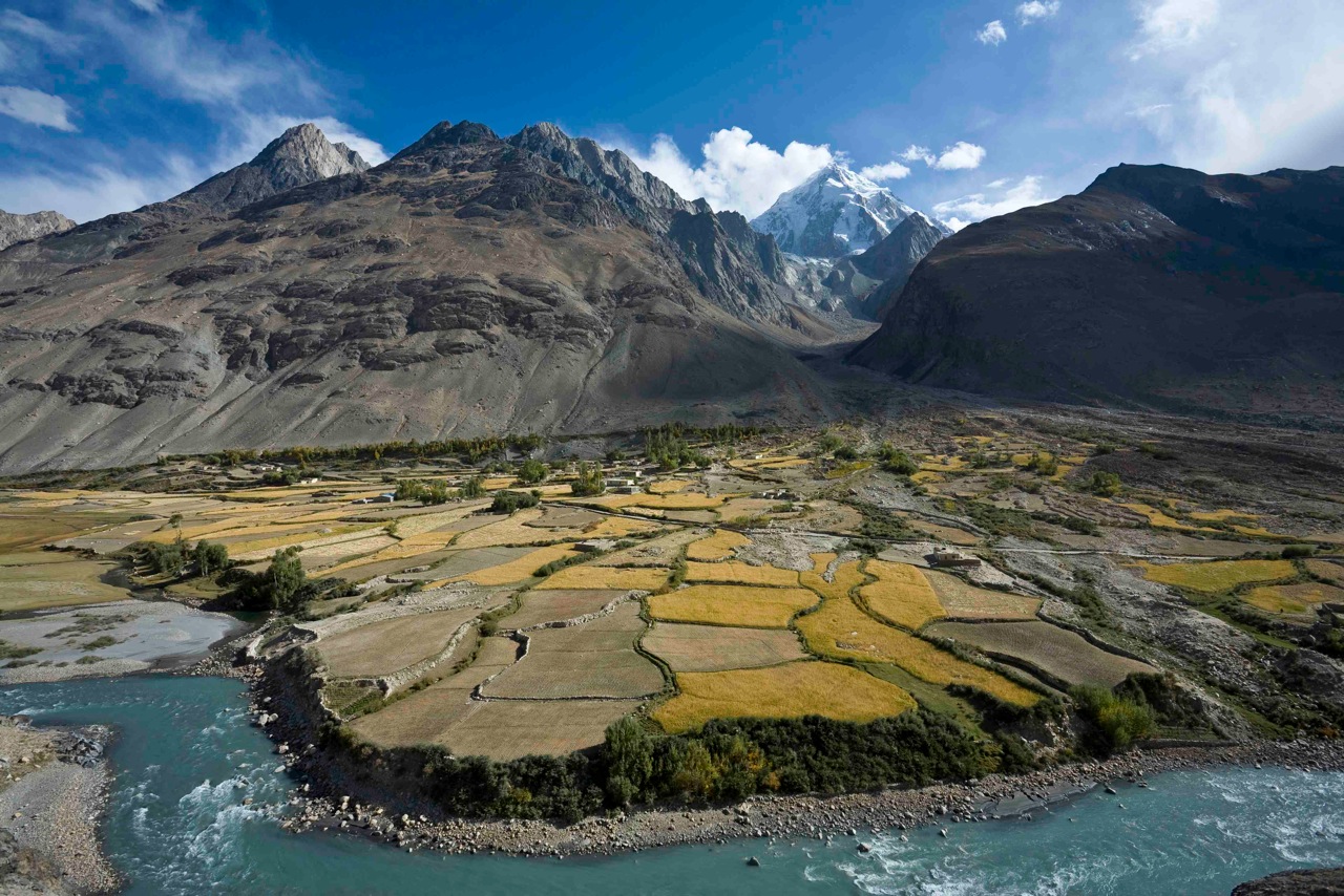
| Beskrivelse | Here, a dramatic view of flood plain cultivation in Wakhan, Afghanistan. Known as "the roof of the world," the Wildlife Conservation Society says the Wakhan Corridor has few rivals in terms of scenic beauty. The little-known area is nestled in the high Pamir Mountains and the region is flanked by the Hindu Kush, Himalayn, Karakoram, and Kunlun ranges. Credit: John Winnie Jr., WCS-Afghanistan |
| Dato | |
| Kilde | FrontLines Environment Photo Contest Winner #5 |
| Forfatter | USAID U.S. Agency for International Development |
| Kameraposition | | Dette og andre billeder på deres position på: OpenStreetMap |
|---|
.jpg¶ms=036.952778_N_0072.962500_E_globe:Earth_type:camera__&language=da)
| Objektposition | | Dette og andre billeder på deres position på: OpenStreetMap |
|---|
.jpg¶ms=036.951111_N_0072.962778_E_globe:Earth_class:object_type:object__&language=da)
The geographical information in this file was retrospectively estimated.
The location may therefore be somewhat imprecise. Verifying and refining these coordinates is strongly encouraged. |
- Notes on location estimate
- Identify village by shape of the farm field
Licensering
This image is a work of a United States Agency for International Development employee, taken or made as part of that person's official duties. As a work of the U.S. federal government, the image is in the public domain in the United States.
See also: The USAID privacy policy and the USAID Office of Inspector General "Disclaimers & Notices" page
|
 |
| This image was originally posted to Flickr by USAID_IMAGES at https://flickr.com/photos/46658241@N06/5808476109. It was reviewed on 4. januar 2017 by FlickreviewR and was confirmed to be licensed under the terms of the United States Government Work. |
Filhistorik
Klik på en dato/tid for at se filen som den så ud på det tidspunkt.
| Dato/tid | Miniaturebillede | Dimensioner | Bruger | Kommentar | |
|---|---|---|---|---|---|
| nuværende | 4. jan. 2017, 04:06 | | 1.280 × 854 (432 KB) | Reguyla | Transferred from Flickr via Flickr2Commons |
Filanvendelse
Der er ingen sider der bruger denne fil.
Global filanvendelse
Følgende andre wikier anvender denne fil:
- Anvendelser på arz.wikipedia.org
- Anvendelser på be.wikipedia.org
- Anvendelser på bg.wikipedia.org
- Anvendelser på ca.wikipedia.org
- Anvendelser på ceb.wikipedia.org
- Anvendelser på cs.wikipedia.org
- Anvendelser på de.wikipedia.org
- Anvendelser på de.wikivoyage.org
- Anvendelser på el.wikipedia.org
- Anvendelser på en.wikipedia.org
- Anvendelser på en.wikivoyage.org
- Anvendelser på eo.wikipedia.org
- Anvendelser på es.wikipedia.org
- Anvendelser på eu.wikipedia.org
- Anvendelser på fa.wikipedia.org
- Anvendelser på he.wikivoyage.org
- Anvendelser på ja.wikipedia.org
- Anvendelser på pl.wikipedia.org
- Anvendelser på pl.wiktionary.org
- Anvendelser på ru.wikipedia.org
- Anvendelser på ru.wikinews.org
- Anvendelser på sv.wikipedia.org
- Anvendelser på ta.wikipedia.org
- Anvendelser på uk.wikipedia.org
- Anvendelser på ur.wikipedia.org
- Anvendelser på www.wikidata.org
- Anvendelser på zh.wikipedia.org
.jpg)