
Fil:PDA Mapping.jpg
Der findes ingen højere opløsning af billedet
PDA_Mapping.jpg (302 × 248 billedpunkter, filstørrelse: 12 KB, MIME-type: image/jpeg)
|
|
Denne fil er fra Wikimedia Commons. Beskrivelsen af filen fra Commons er gengivet nedenfor. |
Beskrivelse
| Beskrivelse |
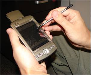
English: A handheld computer with GPS and GIS software is often used for scientific field work. |
| Dato | |
| Kilde | Advanced GIS-Based Field Mapping Techniques for Multi-Disciplinary Research: http://geography.wr.usgs.gov/science/mapping.html |
| Forfatter | US Geological Survey: Nathan Wood |
Licensering
This image is in the public domain in the United States because it only contains materials that originally came from the United States Geological Survey, an agency of the United States Department of the Interior. For more information, see the official USGS copyright policy.
|
Filhistorik
Klik på en dato/tid for at se filen som den så ud på det tidspunkt.
| Dato/tid | Miniaturebillede | Dimensioner | Bruger | Kommentar | |
|---|---|---|---|---|---|
| nuværende | 30. jan. 2009, 22:55 | | 302 × 248 (12 KB) | Awickert | {{Information |Description={{en|1=A handheld computer with GPS and GIS software is often used for scientific field work.}} |Source=Advanced GIS-Based Field Mapping Techniques for Multi-Disciplinary Research: http://geography.wr.usgs.gov/science/mapping.ht |
Filanvendelse
Der er ingen sider der bruger denne fil.
Global filanvendelse
Følgende andre wikier anvender denne fil:
- Anvendelser på en.wikipedia.org
- Anvendelser på ja.wikipedia.org
- Anvendelser på la.wikipedia.org
- Anvendelser på sk.wikipedia.org
- Anvendelser på sv.wikipedia.org
- Anvendelser på vi.wikipedia.org