
Fil:TOMS indonesia smog lrg.jpg
Fuld opløsning (1.234 × 801 billedpunkter, filstørrelse: 337 KB, MIME-type: image/jpeg)
|
|
Denne fil er fra Wikimedia Commons. Beskrivelsen af filen fra Commons er gengivet nedenfor. |
Beskrivelse
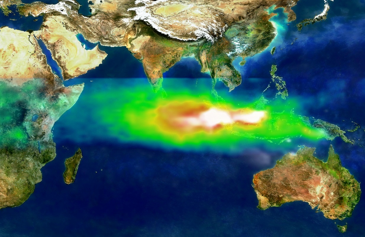
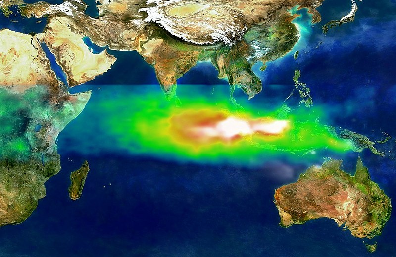
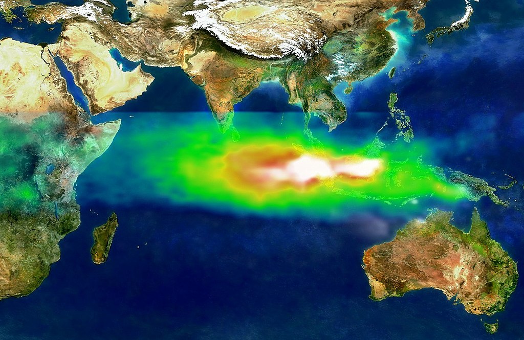
This image shows the pollution over Indonesia and the Indian Ocean on October 22, 1997. White represents the aerosols (smoke) that remained in the vicinity of the fires. Green, yellow, and red pixels represent increasing amounts of tropospheric ozone (smog) being carried to the west by high-altitude winds.
Researchers have discovered that smoke and smog move in different ways through the atmosphere. A series of unusual events several years ago created a blanket of pollution over the Indian Ocean.
In the second half of 1997, smoke from Indonesian fires remained stagnant over Southeast Asia while smog, which is tropospheric, low-level ozone, spread more rapidly across the Indian Ocean toward India.
Researchers tracked the pollution using data from NASA's Earth Probe Total Ozone Mapping Spectrometer (TOMS) satellite instrument. "TOMS is the only satellite instrument that follows both smoke and smog, globally," said Anne Thompson, NASA Earth Scientist at Goddard Space Flight Center, Greenbelt, MD. "The extreme pollution generated during the Indonesian fires was the first time we saw smoke move more slowly and in different directions from where smog moved."
http://visibleearth.nasa.gov/view_rec.php?id=1651
Licensering
| Denne fil er i offentligt domæne i USA fordi den udelukkende er skabt af NASA. NASAs ophavsretspolitik erklærer at materiale udgivet af NASA ikke er omfattet af ophavsret medmindre andet er nævnt. (Se også Template:PD-USGov, NASAs ophavsretspolitik eller JPLs politik for brug af billeder.) | ||
 |
Advarsler:
|
Filhistorik
Klik på en dato/tid for at se filen som den så ud på det tidspunkt.
| Dato/tid | Miniaturebillede | Dimensioner | Bruger | Kommentar | |
|---|---|---|---|---|---|
| nuværende | 12. sep. 2013, 12:18 | | 1.234 × 801 (337 KB) | Soerfm | Crop, contrast |
| 8. sep. 2005, 02:58 |  | 1.280 × 960 (456 KB) | SEWilco | This image shows the pollution over Indonesia and the Indian Ocean on October 22, 1997. White represents the aerosols (smoke) that remained in the vicinity of the fires. Green, yellow, and red pixels represent increasing amounts of tropospheric ozone (smo |
Filanvendelse
Der er ingen sider der bruger denne fil.
Global filanvendelse
Følgende andre wikier anvender denne fil:
- Anvendelser på ar.wikipedia.org
- Anvendelser på cs.wikipedia.org
- Anvendelser på de.wikipedia.org
- Anvendelser på en.wikipedia.org
- Anvendelser på fi.wikipedia.org
- Anvendelser på fi.wikinews.org
- Anvendelser på fr.wikipedia.org
- Anvendelser på id.wikipedia.org
- Anvendelser på ig.wikipedia.org
- Anvendelser på it.wikipedia.org
- Anvendelser på ms.wikipedia.org
- Anvendelser på ru.wikipedia.org
- Anvendelser på ru.wikinews.org
- Anvendelser på sv.wikipedia.org
- Anvendelser på ta.wikipedia.org
- Anvendelser på uk.wikipedia.org
- Anvendelser på vi.wikipedia.org
- Anvendelser på zh.wikipedia.org