
Fil:The Road to the Stars.jpg

Fuld opløsning (5.148 × 3.390 billedpunkter, filstørrelse: 4,07 MB, MIME-type: image/jpeg)
|
|
Denne fil er fra Wikimedia Commons. Beskrivelsen af filen fra Commons er gengivet nedenfor. |
Beskrivelse
| Beskrivelse |
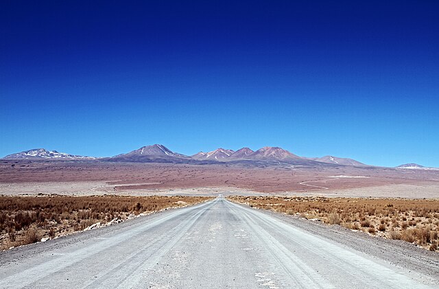
English: This photograph shows the road to the Atacama Large Millimeter/submillimeter Array (ALMA)’s Operations Support Facility (OSF) and then on further to the breathtaking Chajnantor Plateau at 5000 metres above sea level. The plateau, situated in Chilean Puna in the Atacama region, is home to the Array Operations Site (AOS) and is the site of the highest and driest astronomical observatory on Earth.
The OSF is the centre of activities for the ALMA project and is where all staff and contractors are accommodated — only 2900 metres above sea level. This is where all the scientific operations related to the daily operation of the observatory take place. The AOS houses a technical building — the second highest building on Earth — along with the ALMA correlator, the highest and fastest computer ever used at an astronomical site. Due to the high altitude, human operations are kept to a minimum. ALMA will address some of the deepest questions of our cosmic origins as it explores the cool Universe – in particular molecular clouds, star formation and planetary systems. |
||||
| Dato | |||||
| Kilde | http://www.eso.org/public/images/potw1530a/ | ||||
| Forfatter | NAOJ/ALMA (ESO/NAOJ/NRAO) | ||||
| Tilladelse (Genbrug af denne fil) |
|
||||
| Kameraposition | | Dette og andre billeder på deres position på: OpenStreetMap |
|---|
| Annotations | This image is annotated: View the annotations at Commons |
.jpg)
Filhistorik
Klik på en dato/tid for at se filen som den så ud på det tidspunkt.
| Dato/tid | Miniaturebillede | Dimensioner | Bruger | Kommentar | |
|---|---|---|---|---|---|
| nuværende | 14. feb. 2024, 17:47 | | 5.148 × 3.390 (4,07 MB) | C messier | full size |
| 27. jul. 2015, 10:44 |  | 1.280 × 843 (203 KB) | Jmencisom | User created page with UploadWizard |
Filanvendelse
Der er ingen sider der bruger denne fil.
Global filanvendelse
Følgende andre wikier anvender denne fil:
- Anvendelser på en.wikipedia.org
- Anvendelser på sl.wikipedia.org
- Anvendelser på sr.wikipedia.org
- Anvendelser på ur.wikipedia.org