Bruger:Gorbi/Kladde1

Koordinater: 43°42′29″N 1°03′36″Ø / 43.708°N 1.060°Ø / 43.708; 1.060
Fra Wikipedia, den frie encyklopædi
Dokumentation[opret]


en:Template:Infobox French region
Skabelon:Infoboks fransk region

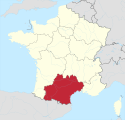
Occitanie[redigér | rediger kildetekst]

Side by side comparison
{{Infoboks fransk region}}{{Bruger:Gorbi/Kladde1}}{{Bruger:Gorbi/Kladde1a}}
Occitanie
[[Fil:|200px|Flag for ]]
Hovedstad Toulouse
Areal 72.724 km²
Regionspræsident Carole Delga
Indbyggertal
 - Indbyggere, år 2009
 - Befolkningstæthed

5.573.000
77 indb./km²
Arrondissementer
Kantoner 269
Kommuner 4.565
Départementer Ariège Ariège
Aude Aude
Aveyron Aveyron
Gard  Gard
Haute-Garonne  Haute-Garonne
Gers  Gers
Hérault  Hérault
Lot Lot
Lozère  Lozère
Hautes-Pyrénées  Hautes-Pyrénées
Pyrénées-Orientales Pyrénées-Orientales
Tarn Tarn
Tarn-et-Garonne Tarn-et-Garonne
Map of
Gorbi/Kladde1

Occitanie
Land Frankrig Frankrig
Kantoner 269
Kommuner 4.565
Præfektur Toulouse
Départementer Ariège Ariège
Aude Aude
Aveyron Aveyron
Gard  Gard
Haute-Garonne  Haute-Garonne
Gers  Gers
Hérault  Hérault
Lot Lot
Lozère  Lozère
Hautes-Pyrénées  Hautes-Pyrénées
Pyrénées-Orientales Pyrénées-Orientales
Tarn Tarn
Tarn-et-Garonne Tarn-et-Garonne
Politik
 • Regionsråds­præsident Carole Delga
Areal
 • Total 72.724 km²
Indbyggertal
 (2009)
 • Total 5.573.000
 • Tæthed 76.632 indb./km²
Tidszone UTC+1 (CET)
 • Sommertid UTC+2 (CEST)
Gorbi/Kladde1
[[File:Map of highlighting {{{county}}}.svg|300px|alt=Kort over med markeret.|Placering i delstaten [[]]]]
Placering i delstaten [[]]
Map of the United States highlighting
placering i USA
Land USA USA
Side by side comparison
{{Infoboks fransk region}}{{Bruger:Gorbi/Kladde1}}{{Bruger:Gorbi/Kladde1a}}
{{{native_name}}}
[[Fil:{{{image_flag}}}|200px|Flag for {{{common_name}}}]]
Hovedstad Toulouse
Areal 72724 km²
Regionspræsident {{{Regional president}}}
Indbyggertal
 - Indbyggere, år 2009
 - Befolkningstæthed

403.257
6 indb./km²
Arrondissementer {{{arrondissements}}}
Kantoner {{{cantons}}}
Kommuner {{{communes}}}
Départementer {{{départements}}}
[[Fil:{{{image_map}}}|200px|Map of {{{common_name}}}]]
Occitanie

Occitània
Occitanies flag
Flag
Occitanies byvåben
Byvåben
Land Frankrig Frankrig
Præfektur Toulouse
Départementer
13
Ariège (09)
Aude (11)
Aveyron (12)
Gard (30)
Gers (32)
Haute-Garonne (31)
Hautes-Pyrénées (65)
Hérault (34)
Lot (46)
Lozère (48)
Pyrénées-Orientales (66)
Tarn (81)
Tarn-et-Garonne (82)
Politik
 • Regionsråds­præsident Carole Delga (Socialist Party)
Areal
 • Total 72724 km²
Indbyggertal
 (2012)
 • Total 5626858
Tidszone UTC+1 (CET)
 • Sommertid UTC+2 (CEST)
Gorbi/Kladde1
flag
Flag
[[File:Map of highlighting {{{county}}}.svg|300px|alt=Kort over med markeret.|Placering i delstaten [[]]]]
Placering i delstaten [[]]
Map of the United States highlighting
placering i USA
Land USA USA
Side by side comparison
{{Infoboks fransk region}}{{Bruger:Gorbi/Kladde1}}{{Bruger:Gorbi/Kladde1a}}
{{{native_name}}}
[[Fil:{{{image_flag}}}|200px|Flag for {{{common_name}}}]]
Hovedstad {{{capital}}}
Areal {{{area}}} km²
Regionspræsident {{{Regional president}}}
Indbyggertal
 - Indbyggere, år 2009
 - Befolkningstæthed

403.257
Fejl i udtrykket: Uventet <-operator. indb./km²
Arrondissementer 36
Kantoner 249
Kommuner 4454
Départementer Ariège (09)
Aude (11)
Aveyron (12)
Gard (30)
Haute-Garonne (31)
Gers (32)
Hérault (34)
Lot (46)
Lozère (48)
Hautes-Pyrénées (65)
Pyrénées-Orientales (66)
Tarn (81)
Tarn-et-Garonne (82)
[[Fil:{{{image_map}}}|200px|Map of {{{common_name}}}]]
Gorbi/Kladde1
Land Frankrig Frankrig
Arrondissementer 36
Kantoner 249
Kommuner 4454
Départementer Ariège (09)
Aude (11)
Aveyron (12)
Gard (30)
Haute-Garonne (31)
Gers (32)
Hérault (34)
Lot (46)
Lozère (48)
Hautes-Pyrénées (65)
Pyrénées-Orientales (66)
Tarn (81)
Tarn-et-Garonne (82)
Indbyggertal
 • Total Skabelon:Population de France/dernière pop
Tidszone UTC+1 (CET)
 • Sommertid UTC+2 (CEST)
Gorbi/Kladde1
[[File:Map of highlighting {{{county}}}.svg|300px|alt=Kort over med markeret.|Placering i delstaten [[]]]]
Placering i delstaten [[]]
Map of the United States highlighting
placering i USA
Land USA USA


Occitania

Occitanie (fransk)
Occitània (occitansk)
A view of Artigues in the Pyrenees
Occitanias flag
Flag
Occitanias byvåben
Byvåben
Koordinater: 43°42′29″N 1°03′36″Ø / 43.708°N 1.060°Ø / 43.708; 1.060
Country  France
Prefecture Toulouse
Departments
13
Ariège (09)
Aude (11)
Aveyron (12)
Gard (30)
Gers (32)
Haute-Garonne (31)
Hautes-Pyrénées (65)
Hérault (34)
Lot (46)
Lozère (48)
Pyrénées-Orientales (66)
Tarn (81)
Tarn-et-Garonne (82)
Politik
 • President of the Regional Council Carole Delga (PS)
Areal
 • Total 72724
 • Rang 3rd
Indbyggertal
 • Total Skabelon:France metadata Wikidata
 • Tæthed auto
Demonym Occitans
Tidszone UTC+01:00 (CET)
 • Sommertid UTC+02:00 (CEST)
ISO 3166-kode FR-OCC
GDP
  • €159 billion (nominal; 2015)[1]
  • $200 billion (PPP; 2016)
GDP per capita €27,449 (nominal; 2015)[2]
Side by side comparison
{{Bruger:Gorbi/Kladde1}}
Gorbi/Kladde1

Occitanie (fransk)
Occitània (occitansk)
Artigues i Pyrenæerne
flag
Flag
byvåben
Byvåben
Koordinater: 43°42′29″N 1°03′36″Ø / 43.708°N 1.060°Ø / 43.708; 1.060{{#coordinates:}}: kan ikke have mere end én primær tag per side
Land Frankrig Frankrig
Kantoner 269
Kommuner 4.565
Præfektur Toulouse
Départementer
13
Ariège Ariège (09)
Aude Aude (11)
Aveyron Aveyron (12)
Gard  Gard (30)
Haute-Garonne  Haute-Garonne (32)
Haute-Garonne  Haute-Garonne (31)
Hautes-Pyrénées  Hautes-Pyrénées (65)
Hérault  Hérault (34)
Lot Lot (46)
Lozère  Lozère (48)
Pyrénées-Orientales Pyrénées-Orientales (66)
Tarn Tarn (81)
Tarn-et-Garonne Tarn-et-Garonne (82)
Politik
 • Regionsråds­præsident Carole Delga (2021-2028) (PS)
Areal
 • Total 72.724 km²
Indbyggertal
 (2009)
 • Total 5.573.000
 • Tæthed 76.632 indb./km²
Tidszone UTC+1 (CET)
 • Sommertid UTC+2 (CEST)
ISO 3166-kode FR-OCC


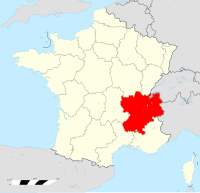
Rhône-Alpes[redigér | rediger kildetekst]

Side by side comparison
{{Infoboks fransk region}}{{Bruger:Gorbi/Kladde1}}{{Bruger:Gorbi/Kladde1a}}
Région Rhône-Alpes
Flag for Rhône-Alpes
Hovedstad Lyon
Areal 43.698 km²
Regionspræsident Jean-Jack Queyranne
Indbyggertal
 - Indbyggere, år 2009
 - Befolkningstæthed

6.174.040
141 indb./km²
Arrondissementer 25
Kantoner 335
Kommuner 2.879
Départementer Ain Ain
Ardèche Ardèche
Drôme  Drôme
Isère Isère
Loire Loire
Rhône Rhône
Savoie Savoie
Haute-Savoie  Haute-Savoie
Map of Rhône-Alpes
Gorbi/Kladde1

Région Rhône-Alpes
flag
Flag
Land Frankrig Frankrig
Arrondissementer 25
Kantoner 335
Kommuner 2.879
Præfektur Lyon
Départementer Ain Ain
Ardèche Ardèche
Drôme  Drôme
Isère Isère
Loire Loire
Rhône Rhône
Savoie Savoie
Haute-Savoie  Haute-Savoie
Politik
 • Regionsråds­præsident Jean-Jack Queyranne
Areal
 • Total 43.698 km²
Indbyggertal
 (2009)
 • Total 6.174.040
 • Tæthed 141.289 indb./km²
Tidszone UTC+1 (CET)
 • Sommertid UTC+2 (CEST)
Gorbi/Kladde1
flag
Flag
[[File:Map of highlighting {{{county}}}.svg|300px|alt=Kort over med markeret.|Placering i delstaten [[]]]]
Placering i delstaten [[]]
Map of the United States highlighting
placering i USA
Land USA USA
Side by side comparison
{{Infoboks fransk region}}{{Bruger:Gorbi/Kladde1}}{{Bruger:Gorbi/Kladde1a}}
{{{native_name}}}
[[Fil:{{{image_flag}}}|200px|Flag for {{{common_name}}}]]
Hovedstad Lyon
Areal 43698 km²
Regionspræsident {{{Regional president}}}
Indbyggertal
 - Indbyggere, år 2009
 - Befolkningstæthed

403.257
9 indb./km²
Arrondissementer {{{arrondissements}}}
Kantoner {{{cantons}}}
Kommuner {{{communes}}}
Départementer {{{départements}}}
[[Fil:{{{image_map}}}|200px|Map of {{{common_name}}}]]
Rhône-Alpes
Rhône-Alpes' flag
Flag
Rhône-Alpes' byvåben
Byvåben
Land Frankrig Frankrig
Præfektur Lyon
Départementer
8+1 Metropolis
Ain
Ardèche
Drôme
Isère
Loire
Rhône
Savoie
Haute-Savoie
Metropolis of Lyon
Areal
 • Total 43698 km²
Indbyggertal
 (2014-01-01)
 • Total 6449000
Tidszone UTC+1 (CET)
 • Sommertid UTC+2 (CEST)
ISO 3166-kode FR-V
BNP (2014)[3] nr. 2nd
Total 207 milliarder euro (US$228 bn)
pr. indbygger €32,000 (US$35,200)
NUTS-region FR7
Hjemmeside www.rhonealpes.fr
Gorbi/Kladde1
flag
Flag
[[File:Map of highlighting {{{county}}}.svg|300px|alt=Kort over med markeret.|Placering i delstaten [[]]]]
Placering i delstaten [[]]
Map of the United States highlighting
placering i USA
Land USA USA
Side by side comparison
{{Infoboks fransk region}}{{Bruger:Gorbi/Kladde1}}{{Bruger:Gorbi/Kladde1a}}
{{{native_name}}}
[[Fil:{{{image_flag}}}|200px|Flag for {{{common_name}}}]]
Hovedstad {{{capital}}}
Areal {{{area}}} km²
Regionspræsident {{{Regional president}}}
Indbyggertal
 - Indbyggere, år 2009
 - Befolkningstæthed

403.257
Fejl i udtrykket: Uventet <-operator. indb./km²
Arrondissementer 25
Kantoner 335
Kommuner 2879
Départementer Ain (01)
Ardèche (07)
Drôme (26)
Isère (38)
Loire (42)
Rhône (69)
Métropole de Lyon (69)
Savoie (73)
Haute-Savoie (74)
[[Fil:{{{image_map}}}|200px|Map of {{{common_name}}}]]
Gorbi/Kladde1
Land Frankrig Frankrig
Arrondissementer 25
Kantoner 335
Kommuner 2879
Départementer Ain (01)
Ardèche (07)
Drôme (26)
Isère (38)
Loire (42)
Rhône (69)
Métropole de Lyon (69)
Savoie (73)
Haute-Savoie (74)
Indbyggertal
 • Total 6449000
Tidszone UTC+1 (CET)
 • Sommertid UTC+2 (CEST)
Gorbi/Kladde1
[[File:Map of highlighting {{{county}}}.svg|300px|alt=Kort over med markeret.|Placering i delstaten [[]]]]
Placering i delstaten [[]]
Map of the United States highlighting
placering i USA
Land USA USA
  1. ^ "Produits intérieurs bruts régionaux et valeurs ajoutées régionales de 1990 à 2015 | Insee".
  2. ^ "Produits intérieurs bruts régionaux et valeurs ajoutées régionales de 1990 à 2015 | Insee".
  3. ^ http://ec.europa.eu/eurostat/documents/2995521/7192292/1-26022016-AP-EN.pdf/602b34e8-abba-439e-b555-4c3cb1dbbe6e
  4. ^ Source Insee