Bruger:PHansen/Beskyttet område fejlmelding
Udseende
Vedrørende
[redigér | rediger kildetekst]- embedded ==> child i "Skabelon:Infoboks beskyttet område#With_embedded_alternate_map
- en:Template:Infobox_protected_area#With_embedded_alternate_map
- man kan få samme resultat med adfadfh =
Problemer med {{Location_map}} og {{coord}} ? find på engl
[redigér | rediger kildetekst]- en:Template:Location map har den danske {{Kortpositioner}} på Wikidata: Template:Location map (d:Q5625881), Wikimedia template
Parameter 'embedded' -- Problemet er formentlig {{Location map}} med {{Coord}}
[redigér | rediger kildetekst]Man kan fjerne Lua-fejlmeldingen ved fx at skrive qwerty eller lignende, så forsvinder den røde melding
- "Lua-fejl i Modul:Location_map på linje 353: Malformed coordinates value."
..men kortet vises ikke. Derfor bør /doc tilbagestilles fra 'child' til 'embedded' så fejlen er synlig igen
NEGATIV: With embedded alternate map -- Her med {{Coord}}
[redigér | rediger kildetekst]| Black Forest National Park | |
|---|---|
IUCN kategori II (nationalpark) | |
| Location of the Black Forest National Park in the northwestern Black Forest | |
| Sted | Baden-Württemberg, Tyskland |
| Koordinater | 48°33′40″N 8°13′17″Ø / 48.56111°N 8.22139°Ø |
{{Infoboks beskyttet område
| name = Black Forest National Park
| iucn_category = II
| map = Nationalpark-Schwarzwald-Lageplan.png
| map_alt =
| map_caption = Location of the Black Forest National Park in the northwestern Black Forest
| map_width =
| relief =
| location = [[Baden-Württemberg]], Tyskland
| coordinates     = {{coord|48|33|40|N|8|13|17|E| display = inline <!-- for documentation page only - not general practice -->}}
| embedded = {{Location map | Tyskland
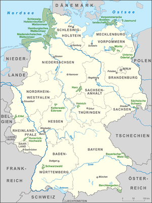
 | AlternativeMap = Karte Nationalparks Deutschland high.png
 | caption = Black Forest National Park in the southwest of the map
 | coordinates     = {{coord|48|33|40|N|8|13|17|E}}
 | border = none
 | width = 300
 }}
}}
POSITIV: With embedded alternate map -- Samme data, men med bredde_grad osv i stedet for Coord
[redigér | rediger kildetekst]| Black Forest National Park | |
|---|---|
IUCN kategori II (nationalpark) | |
| Location of the Black Forest National Park in the northwestern Black Forest | |
| Sted | Baden-Württemberg, Tyskland |
| Koordinater | 48°33′40″N 8°13′17″Ø / 48.56111°N 8.22139°Ø |
{{Infoboks beskyttet område
| name = Black Forest National Park
| iucn_category = II
| map = Nationalpark-Schwarzwald-Lageplan.png
| map_alt =
| map_caption = Location of the Black Forest National Park in the northwestern Black Forest
| map_width =
| relief =
| location = [[Baden-Württemberg]], Tyskland
| coordinates     = {{coord|48|33|40|N|8|13|17|E| display = inline <!-- for documentation page only - not general practice -->}}
| embedded = {{Location map | Tyskland
 | AlternativeMap = Karte Nationalparks Deutschland high.png
 | caption = Black Forest National Park in the southwest of the map
<!-- | coordinates     = {{coord|48|33|40|N|8|13|17|E}}
| bredde_grad=48
| bredde_min=33
| bredde_sek=40
| bredde_ret=N
| længde_grad=8
| længde_min=13
| længde_sek=17
| længde_ret=E

>>>>>> NB Lua-modulet kræver
       tilsyneladende engelske
       parameterbetegnelser
-->
| lat_deg    = 48
| lat_min    = 33
| lat_sec    = 40
| lat_dir    = N
| lon_deg    = 8
| lon_min    = 13
| lon_sec    = 17
| lon_dir    = E

 | border = none
 | width = 300
 }}
}}


