San Andreas-forkastningen: Forskelle mellem versioner
Content deleted Content added
Add 1 book for Wikipedia:Verificerbarhed (20210320)) #IABot (v2.0.8) (GreenC bot |
Oprettede eller redigerede 3 arkivlinks ud af 14 analyserede links, se hjælp) #IABot (v2.0.8.6 |
||
| Linje 30: | Linje 30: | ||
== Eksterne henvisninger == |
== Eksterne henvisninger == |
||
* [http://quake.wr.usgs.gov/research/parkfield/index.html The Parkfield Experiment] |
* [http://quake.wr.usgs.gov/research/parkfield/index.html The Parkfield Experiment] |
||
* [http://www.icdp-online.de/sites/sanandreas/index/index.html San Andreas Fault Observatory at Depth] |
* [http://www.icdp-online.de/sites/sanandreas/index/index.html San Andreas Fault Observatory at Depth] {{Webarchive|url=https://web.archive.org/web/20040401205920/http://www.icdp-online.de/sites/sanandreas/index/index.html |date= 1. april 2004 }} |
||
* [http://www.data.scec.org/fault_index/sanandre.html Southern California Earthquake Data Center: San Andreas Fault] |
* [http://www.data.scec.org/fault_index/sanandre.html Southern California Earthquake Data Center: San Andreas Fault] {{Webarchive|url=https://web.archive.org/web/20070518064426/http://www.data.scec.org/fault_index/sanandre.html |date=18. maj 2007 }} |
||
* [http://pubs.usgs.gov/gip/earthq3/ USGS: The San Andreas Fault] |
* [http://pubs.usgs.gov/gip/earthq3/ USGS: The San Andreas Fault] |
||
* [http://scotthaefner.com/kap/360panos/image.php?i=sanandreas.mov 360 panorama of the Carrizo Plain section of the fault taken from a Kite] |
* [http://scotthaefner.com/kap/360panos/image.php?i=sanandreas.mov 360 panorama of the Carrizo Plain section of the fault taken from a Kite] |
||
* [http://scrippsnews.ucsd.edu/article_detail.cfm?article_num=736 Scripps Institution of Oceanography (University of California, San Diego) study indicating that an earthquake of magnitude 7.0 or greater is "overdue."] |
* [http://scrippsnews.ucsd.edu/article_detail.cfm?article_num=736 Scripps Institution of Oceanography (University of California, San Diego) study indicating that an earthquake of magnitude 7.0 or greater is "overdue."] {{Webarchive|url=https://web.archive.org/web/20070302142343/http://scrippsnews.ucsd.edu/article_detail.cfm?article_num=736 |date= 2. marts 2007 }} |
||
* [http://quake.wr.usgs.gov/kap/carrizo/ Source for the Carrizo Plain images (USGS)] |
* [http://quake.wr.usgs.gov/kap/carrizo/ Source for the Carrizo Plain images (USGS)] |
||
* [http://www.exploratorium.edu/faultline/liveeye.html Live Eye on the Earth] |
* [http://www.exploratorium.edu/faultline/liveeye.html Live Eye on the Earth] |
||
Versionen fra 12. jan. 2022, 16:40


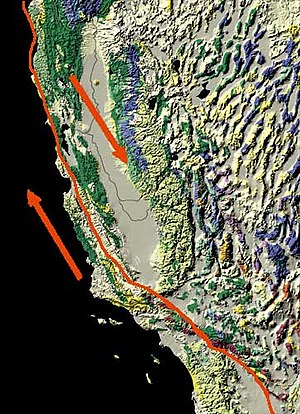
San Andreas-forkastningen er en geologisk forkastning som strækker sig 1300 km gennem den vestlige og sydlige del af Californien. Forkastningen er den tektoniske grænse mellem Stillehavspladen og den amerikanske kontinentalplade. Den relative bevægelse af kontinentalpladerne er 33-39 mm pr år.
San Andreas forkastningen er blot en af mange forkastninger langs pladegrænserne mellem den nordamerikanske kontinentalplade og Stillehavspladen, Juan de Fuca-pladen og Cocospladen, som f.eks. Elisnore-forkastningen syd-øst for Los Angeles.[1]
Betydelige jordskælv
San Andreas-forkastningen har har haft nogle betydelige jordskælv i historisk tid:
- 1857 Fort Tejon-jordskælvet. Styrke omkring 8,0.
- Jordskælvet i San Francisco 1906 Styrke omkring 7,8.
- 1989 Loma Prieta-jordskælvet. Styrke omkring 7,1.
- 2004 Parkfield-San Bernardino-jordskælvet. Styrke omkring 6,0.
Se også
Referencer
- Collier, Michael (1. december 1999). A Land in Motion. UC Press. ISBN 0-520-21897-3.
- Stoffer, Philip W. (2006). Where's the San Andreas fault? A guidebook to tracing the fault on public lands in the San Francisco Bay region. USGS. General Interest Publication 16.
- Lynch, David K. (2006). Field Guide to the San Andreas Fault: See and Touch the World's Most Famous Fault on any one of Twelve Easy Day Trips. Thule Scientific. Full color, GPS coordinates, ISBN 0-9779935-0-7.
Eksterne henvisninger
- The Parkfield Experiment
- San Andreas Fault Observatory at Depth Arkiveret 1. april 2004 hos Wayback Machine
- Southern California Earthquake Data Center: San Andreas Fault Arkiveret 18. maj 2007 hos Wayback Machine
- USGS: The San Andreas Fault
- 360 panorama of the Carrizo Plain section of the fault taken from a Kite
- Scripps Institution of Oceanography (University of California, San Diego) study indicating that an earthquake of magnitude 7.0 or greater is "overdue." Arkiveret 2. marts 2007 hos Wayback Machine
- Source for the Carrizo Plain images (USGS)
- Live Eye on the Earth
- Latest Earthquakes (USGS)
- Andrew Lawson: Discoverer of the San Andreas Fault
- The Day California Cracks at BusinessWeek online (09/19/05)
- Waiting for the big one by Shannon Brownlee (July 1986)
 |
Wikimedia Commons har medier relateret til: |
